ALL-DAY WEEKEND
Sunday No. A2202-938-10459 Apr 03, 2022
Waterrock Knob to The Pinnacle 8:00 AM
Hike 9.2, Drive 90, 1560 ft. ascent, Rated A-A, sb6k
Mike Knies, 828-628-6712, knies06@att.net
Only Meeting Place: Home Depot off Exit 44 of I-40. This hike will begin from the Waterrock Knob lower parking lot and continue along a rough trail, passing Yellow Face and mega rock formations, and on to the spectacular view from Blackrock Mtn. From there we will descend a bit and then hike out to even more spectacular views of craggy Pinnacle Park. We will then backtrack a short distance before descending steeply to our vehicles at the Fisher Creek Trailhead. 30-minute car shuttle. If the parkway is closed, another hike will be announced.
Saturday No. A2202-529-10432 Apr 09, 2022
Fletcher Fields and Spencer Branch 10:00 AM
Hike 8.9, Drive 40, 1200 ft. ascent, Rated B-B, p400
Carroll Koepplinger, 828-231-9444, cakoep29@gmail.com
First Meeting Place: Asheville Outlets parking lot behind Waffle House off Exit 33 of I-26.
Second Meeting Place: Ingles on NC 191/280 N end of parking lot in front of Pardee Urgent Care (Mills River) at 10:15 AM
Follow Fletcher Field Trail to end and return on Spencer Branch past Hendersonville Reservoir and back to cars.
Topo(s): Dunsmore Mt
hike report:
Due to weather conditions on the scheduled date this hike was rescheduled for Sunday, April 10th. Five hikers enjoyed a beautiful sunny spring day with temps reaching into the 60's. The trails were in excellent conditions except for a few muddy sections. We started the hike at 10:50 am and after 8.9 mi returned at 4 pm. We had four wet stream crossings, a couple of which were partial rock hopping's. One hiker had her wet stream crossing "baptism" with nothing hurt but pride! We only meet 2 other hikers on the trail near the reservoir prior to the end of the hike. There were numerous bikers on the trails. We encountered the very unusual contact with two different groups (5-6) of bikers that stopped and waited to let us proceed without any interference on their part. In both instances they stated that they honored the trail guidelines as they relate to which group has the right of way -WOW, how often have we had that experience? Very refreshing, to say the least. Another great CMC hike!! Carroll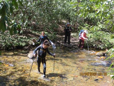
scout report:
Bruce and I scouted this hike Fri. Apr. 1st. The trail overall is in very good condition. Due to the recent rainfalls the streams were flowing with a considerable amount of flow. We had three wet crossings and several rock hopping or with little depth that one can cross without getting more than the bottom inch or so of your boots wet. Depending on the rain conditions between now and Sat. Apr. 9th, that will determine the depth of the water level. Even if little or no rain falls you will need to be prepared for up to three wet crossings. This is a good hike with mostly gradual ascents. CarrollSunday No. A2202-142-10438 Apr 10, 2022
Jerry Miller Trail to A.T. 8:00 AM
Hike 10.0, Drive 92, 2400 ft. ascent, Rated A-AA, at-mst
Tish Desjardins, 828-380-1452, desraylet@aol.com
First Meeting Place: 160 Zillicoa St. (USFS parking lot) off Exit 25 of I-26.
Second Meeting Place: Corner of US 25/70 & NC 208 at 8:30 AM
Form carpools and meet leader at second meeting place. We’ll hike up the Jerry Miller Trail to Bearwallow Gap, then right on the A.T. to Big Firescald Knob for lunch and exceptional views. We'll return on the Jerry Miller Trail.
Topo(s): Greystone
hike report:
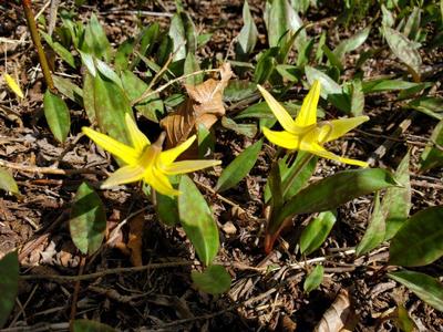
It was a gorgeous, sunny day after the prior day's snowfall. We walked on a few inches of snow which was slightly deeper, but packed down from the thru-hikers once we got up on the ridge of the A.T. The view was beautiful, as usual, up on Firescald Knob. But, this time, it had the extra beauty of snow complementing the distant peaks. Coming back down, the snow had melted a great deal and the Trilliums were in bloom along with the Trout Lillies, Spring Beauties, and Dutchman's Breeches. Wonderful Appalachian Spring!Sunday No. A2202-454-10437 Apr 17, 2022
Porters Creek Trail 8:30 AM
Hike 7.6, Drive 160, 1500 ft. ascent, Rated B-B,
Danny Bernstein, 828-450-0747, dannyhiker@gmail.com
First Meeting Place: Home Depot off Exit 44 of I-40.
Second Meeting Place: Pilot Truck Stop off Exit 24 of I-40 at 9:00 AM - but contact leader first.
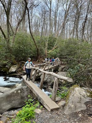
900M This trail in Great Smoky Mountains National Park is famous for its wildflower displays in March and April. We will first pass the remnants of old homesteads and the Owenby cemetery before entering a moist sheltered cove with large trees, masses of wildflowers (we hope) and a rushing creek. This hike is #25 of the 100 Favorite Trails. CMC members only, no guests. You must be fully vaccinated against the COVID-19 virus.
Topo(s): Mt Le Conte
hike report:
A wonderful, classic hike in the Smokies. Today the flowers were abundant, the weather was perfect and the group so congenial and social. What a wonderful day!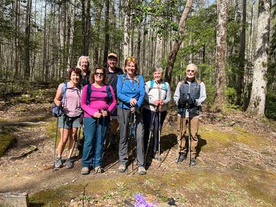
Saturday No. A2202-548-10460 Apr 23, 2022
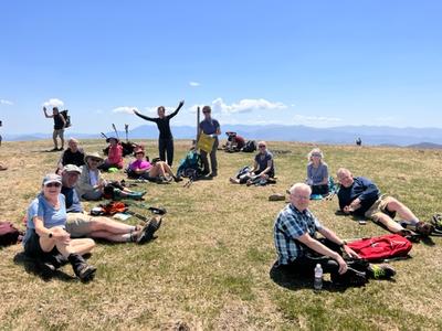
Sams Gap to Big Bald 8:00 AM
Hike 13.0, Drive 50, 3300 ft. ascent, Rated AA-AA+, at-mst
Judy Magura, 828-606-1490, quilter290@gmail.com and Jim Magura, 828-606-3989, jqs290@gmail.com
Only Meeting Place: 160 Zillicoa St. (USFS parking lot) off Exit 25 of I-26. Form carpools and meet leaders at the trailhead. Follow A.T. north from Sams Gap to Big Bald, then reverse direction to start point. Beautiful views along the way! This hike is #46 of the 100 Favorite Trails.
Topo(s): Sams Gap
hike report:
Great hike under full sun with 12 hikers. The AT was in great shape for this hike including the upper section we used for the climb up to the bald. One of our best views, of the bald in full sun was at the start and end of the hike from the old apple orchard field at the top of our first climb. In photo 1, the hike point is the bald. It was as far away as it looked. The long range view gave us a bit of encouragement, but it was well over 4 miles away at this point. But the view was spectacular. We found the AT a bit rocky in spots , but completely cleared. We encountered quite a few hikers going north on the AT, and there were a number of 'Trail Magic' stops we passed through on the way up and down the six mile trail to the top. But we chatted a bit but did not take any of the goods that were available for the AT hikers. We also met Tim Carrigan who maintains the member site and the AT section though the Bald on the trail. Photo 2 is our lunch break after the climb up Big Bald. Too tired to stand! One of our best but difficult 100 favorite hikes.
Sunday No. A2202-406-10435 Apr 24, 2022
Club Gap to Clawhammer Mtn. 8:30 AM
Hike 7.5, Drive 75, 2300 ft. ascent, Rated B-AA, p400
Lorraine Bernhardt, 828-699-8857, lsbernhardt50@gmail.com
First Meeting Place: Asheville Outlets parking lot behind Waffle House off Exit 33 of I-26.
Second Meeting Place: Pisgah Forest Walmart parking (back of center aisles close to Taco Bell) at 9:00 AM
Form carpools and meet leader at the second meeting place. We will climb from the Pink Beds (FS 477) to Club Gap. Then we take the Black Mountain Trail, climbing through Buckhorn Gap and along the ridge to the overlook at Clawhammer Mountain for lunch and 180-degree views. This hike is #66 of the 100 Favorite Trails.
Topo(s): Pisgah Forest,Shining Rock
scout report:
I learned that this is a popular biking trail. We saw multiple groups of bikers, including a team from Michigan. It wasn’t a problem, they shared the trail courteously. It is fairly steady uphill with the steepest section just prior to Clawhammer. The views hiking along the ridge were just beautiful. We can decide if we want to continue a little further on to Black Mountain. We clocked in 8 miles and just under 2200 feet. Thanks to Donna for scouting it with me.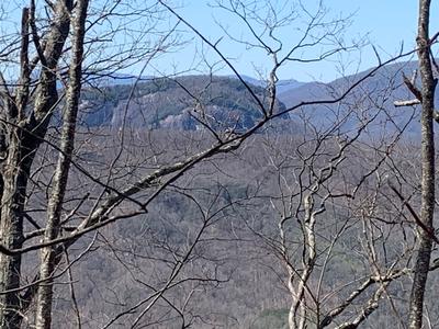
hike report:
We had a group of 8 on this beautiful spring day. The greening of the trees obscured some of the views enjoyed on the scout hike. The occasional breeze was welcome as we climbed under sunny skies. The first challenge was parking as the few spaces at the trail head were occupied. We parked on the road, hugging the narrow shoulder. There was a large group of hikers at the shelter who had spent the night. We also encountered bikers as expected. It was a good day to be in the woods.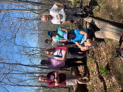
Monday No. A2202-954-10498 Apr 25, 2022
Clingmans Dome to Fontana Lake 7:30 AM
Hike 22.0, Drive 160, 1100 ft. ascent, Rated AA-B,
Mike Knies, 828-628-6712, knies06@att.net
Only Meeting Place: Clingmans Dome parking lot. 900M This is a fabulous opportunity to have a great hike (mostly downhill 5500 ft.) on trails that are logistically very difficult to reach. Mike Knies and others are planning a boat/bus combination between Clingmans Dome and Proctor via either the Hazel Creek or Welch Ridge/Cold Spring Trails with the Margaret Stevenson Hiking Group and the Smoky Mountain Hiking Club. A boat charter will be organized to pick up hikers at the Hazel Creek boat launch and transfer to Cable Cove, where a bus will be chartered to take hikers back to Clingmans Dome. It will be a “shotgun” start from Clingmans Dome, with hikers to be responsible for adjusting their start time to meet the boat pickup time(s) (likely between 5pm and 5:30pm). There will be an option for an additional 3.6 miles to Bone Valley. Cost will depend on the number of hikers but likely to be Boat: $25+$5 tip and Bus: $20 including tip. Please email Mike with your preferred route / Bone Valley option.
Sunday No. A2202-249-10434 May 01, 2022
Buckeye Gap and Haywood Gap Trails Circuit 8:30 AM
Hike 9.6, Drive 70, 1950 ft. ascent, Rated A-A, Wilderness hike, limited to ten hikers, contact leader for reservation. p400
Henry Kassell, 845-656-5528, hkassell@gmail.com
First Meeting Place: Asheville Outlets parking lot behind Waffle House off Exit 33 of I-26.
Second Meeting Place: BRP Cold Mountain Overlook at MM 412 at 9:15 AM
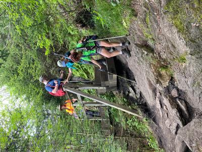
We'll hike the MST and the Buckeye Gap Trail in the Middle Prong Wilderness, down a ridgeline on an old logging railroad grade and past an old logging camp. At the junction with the Haywood Gap Trail, we'll turn right down to the lower end of the Haywood Gap Trail, then turn around and hike steeply up alongside Haywood Gap Stream to Haywood Gap. Note: This hike can be tougher than it appears, with a steep downhill and arduous uphill, and three possibly wet crossings. Short car shuttle.
Topo(s): Sam Knob
hike report:
Three hikers (myself inc.) set out on this hike in mixed sun and clouds. The anticipated bad weather was a no-show. We hike counterclockwise on this upside down lollipop hike. The Buckeye Trail is a pleasant walk on an old railroad grade until the trail diverges away from the grade and heads steeply down to it's meeting with the Haywood Gap Tr. There was a profusion of the usual wildflowers but also a hillside of ramps on the downhill section. Once on the Haywood Gap Trail we turned right (north) and lunched at the end near a cascade. The return trip along the Middle Prong of the East Fork of the Pigeon River was pleasant until the last third which climbs steeply to the parkway. We were greeted at the crest by open woods with May Apples and Trilliums.
scout report:
Saturday No. A2202-172-10475 May 07, 2022
John Rock Loop Hike 10:00 AM
Hike 6.2, Drive 60, 1300 ft. ascent, Rated B-B, p400,wc100
Barbara Morgan, 828-460-7066, barbc129@gmail.com
First Meeting Place: Asheville Outlets parking lot behind Waffle House off Exit 33 of I-26.
Second Meeting Place: Pisgah Forest Fish Hatchery off FS 475 at 10:30 AM
This moderate loop hike, with good views from John Rock, starts at the Fish Hatchery parking lot. We will do a loop hike, using the Cat Gap and John Rock Trails. This hike is #61 of the 100 Favorite Trails.
Topo(s): Shining Rock
scout report:
We scouted this 5/4/22 and a couple of things have changed in a nice way. A replacement bridge near the start has been completed (as of Saturday!), which reopens that part of the trail. Also, the parking area which had been severely impacted by Fred's flooding is back to normal size. FYI, the Wildlife Center is still closed, so there are no restroom facilities or portajohns at the trailhead. At this point, weather looks great - highs of about 62 and almost no chance of rain. Much better than the 85 degrees we sweated through yesterday. We'll do the hike in a clockwise direction and after our stop for lunch on John Rock, we'll continue up till we reach the Cat Gap Loop bypass trail and take it instead of the Cat Gap Loop trail, saving some extra climbing just to come back down. (This hike is #61 of the 100 Favorite Hikes challenge, and I hope doing the bypass doesn't interfere with "counting" this hike toward your challenge completion.) Then we'll rejoin the Cat Gap Loop trail back to the parking lot. Yesterday we met for our carpool at 9:00 and finished hiking at 2:30, so expect about an hour later due to our 10:00 meeting time on Saturday. Do bring poles - there are several rock-hops and a portion of the trail with rocks/roots/ and big step-downs.hike report:
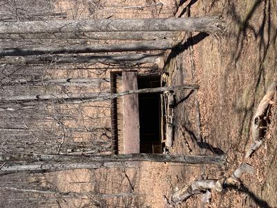
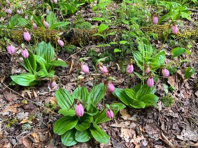
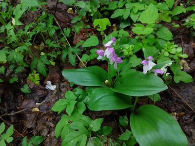
Eight of us gathered at the Fish Hatchery/Wildlife Ed parking lot for a loop hike using Cat Gap Loop and John Rock trails, going clockwise. We started with Some info about the CCC Camp John Rock there from the depression days and a view of where we were going - John Rock itself. One real treat was the largest patch of pink ladyslippers any of us have ever seen! Thankfully the temperature was around 65 - much, much cooler than the day we scouted it. Lunch on the rock was nice - there were others there, but it wasn't crowded at all. Afterward, the going got slower as we headed to the Cat Gap bypass trail, then was nicer as we finished the loop. Many thanks to all for a great day, but special thanks to Danny B for helping in several ways and to Carroll K for locating the side-trail to a waterfall near the end of the hike.
Sunday No. A2202-89-10467 May 08, 2022
Lemon Gap to Max Patch 8:00 AM
Hike 10.8, Drive 100, 1600 ft. ascent, Rated A-A, at-mst
Michael Cornn, 828-458-1281, mwcornn@gmail.com and Kathy Cornn/Kyle, 828-458-1282, katherinenkyle@gmail.com
First Meeting Place: Home Depot off Exit 44 of I-40.
Second Meeting Place: Pilot Truck Stop off Exit 24 of I-40 at 8:30 AM - but contact leader first.
Early May is a good time to see a beautiful display of white trilliums blooming along the trail. We’ll see the A.T. shelter built by the CMC along a beautiful section of the A.T. We will begin at Lemon Gap, have lunch on top of Max Patch with its beautiful views and return to our cars at Lemon Gap. This hike is #40 of the 100 Favorite Trails.
Topo(s): Hot Springs
hike report:
Eight were on the hike from Lemon Gap to Max Patch for this classic hike with a long, but scenic drive to the trailhead on a well maintained dirt road. We met several thru-hikers on the AT and at the top of Max Patch. We also met a Max Patch Ambassador at the top of Max Patch. Trillium, wild geranium, showy orchid and lady slipper were among the wildflowers we saw. We stopped for part of our lunch at Roaring Fork Shelter. Then we had the other half of our lunches on top of Max Patch. Skies were cloudy, but the spring colors were vivid. Max Patch was spotless with no trash seen. We reported one down tree along the AT, which was about 40 minutes from Lemon Gap. We took an alternative route to Lemon Gap. We got off on Exit 27 on I-40 where the Pilot Gas Station is to access Max Patch Road. This seemed to be a better road than the route listed in the database.
Sunday No. A2202-839-10433 May 15, 2022
Pink Beds, S. Mills River, Soapstone Ridge loop 8:30 AM
Hike 9.0, Drive 70, 1350 ft. ascent, Rated B-B, p400
Bruce Bente, 828-692-0116, cell 828-567-9443, bbente@bellsouth.net
First Meeting Place: Asheville Outlets parking lot behind Waffle House off Exit 33 of I-26.
Second Meeting Place: Pisgah Forest Walmart parking (back of center aisles close to Taco Bell) at 9:00 AM
Form carpools and meet leader at second meeting place. We'll do a long loop, starting with parts of the Pink Beds Loop and S. Mills River Trails, and returning via Soapstone Ridge, left at Barnett Branch Trail, right onto an old road and past the old steam locomotive.
Topo(s): Pisgah Forest,Shining Rock
scout report:
Two of us scouted the hike last Saturday. It is a 9.8 mile loop with about 1300' of ascent. The hike begins with 3.6 miles on the left side of the Pink Beds Loop. The trail crosses creeks three times. The first two crossings require wading water that is just below topping of hiking boots, and the third is a rock hop. If the water levels are higher on the hike, the second crossing might become a wet crossing. After the last crossing, we'll have an early lunch on rocks at the gauging station, and then follow the Mills River Trail for a mile. Next is a turn onto an unmarked but passable trail over to the Barnett Branch Trail. This trail is followed for a mile, and then we turn onto an old unused forest road down to one of the Cradle of Forestry trails, and follow it past the logging locomotive and logging train and back to the cars, using the best route available to us.Sunday No. A2202-862-10468 (canceled) May 22, 2022
Cove Creek Gap - Hemphill Bald 8:00 AM
Hike 11.0, Drive 70, 1800 ft. ascent, Rated A-A,
Donna Lanning, 828-606-7956, dblanning@bellsouth.net
Only Meeting Place: Home Depot off Exit 44 of I-40. 900M This revised version of hike #862 will follow Cataloochee Divide Trail, with great views of valleys and distant mountains, then do a loop past the Ferguson Cabin and Science Center and then return on Cataloochee Divide Trail. Hike limited to ten hikers.
Topo(s): Cove Creek Gap
scout report:
Lorraine and I scouted on a chilly, cloudy day which included a brief shower at lunch. This hike begins at Cove Creek Gap which is on the way to Cataloochee Valley on Cove Creek Rd. We begin on the Cataloochee Divide trail which often follows the fenced border of the park and is very scenic. We will turn onto the Ferguson Cabin trail and explore the cabin and some history, then walk up to the park’s Appalachian Highlands Science Learning Center, which is used for educational school-related trips and internships. I think it will be closed but it’s very interesting seeing it on top of Purchase Knob and it has very nice views. We will then return to the Divide trail and back to the cars. This is a variation of the original hike because we can no longer leave a shuttle car on Purchase Rd. It will be an in and out hike. It is also hike #36 of the 100 favorite trails challenge. Donnahike report:
Saturday No. A2202-239-10470 (canceled) May 28, 2022
Craggy Gardens Picnic Area to Craven Gap 8:30 AM
Hike 10.2, Drive 30, 1800 ft. ascent, Rated A-A, at-mst
Brenda Worley, 828-684-8656, cell 828-606-7297, bjdworley@gmail.com
Only Meeting Place: Back parking lot of Folk Art Center. An MST hike with good views, varied forest terrain and many wildflowers. We will hike over Lane Pinnacle, past the Rattlesnake Lodge site, and then do an easy 4-mile section with little elevation change. Car shuttle.
Topo(s): Craggy Pinnacle
hike report:
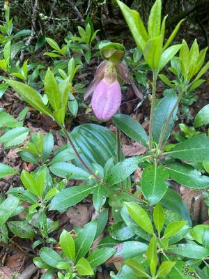
Five of us, including a new CMC hiker, started out in windy-chilly weather which soon turned warm and partly sunny. We had good trail conditions and saw several wildflowers along the trail. Columbine, Pink Lady Slipper, Virginia Waterleaf and Yellow Beaded Lily were some of the wildflowers still blooming.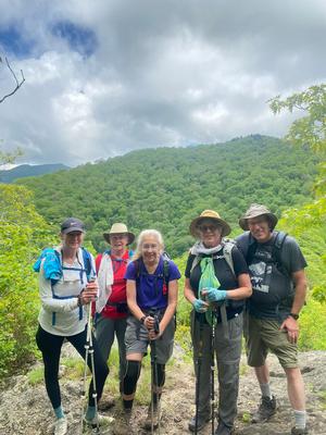
scout report:
Saturday No. A2202-76-10567 May 28, 2022
Bee Tree Gap to Little Snowball 8:30 AM
Hike 7.2, Drive 43, 2600 ft. ascent, Rated B-AA, ltc
Brenda Worley, 828-684-8656, cell 828-606-7297, bjdworley@gmail.com
Only Meeting Place: Back parking lot of Folk Art Center. From Bee Tree Gap, we’ll take the Snowball Trail to High Rocks (Hawkbill Mountain), and then on to the old lookout site atop Little Snowball. Return via the same route. If the day is clear, we will have great views from High Rocks and Little Snowball.
Topo(s): Craggy Pinnacle
hike report:
Sunday No. A2202-950-10465 May 29, 2022
Fork Ridge - Noland Divide 7:30 AM
Hike 15.7, Drive 140, 3400 ft. ascent, Rated AA-AA+,
Cindy McJunkin, 828-712-9646, mcjfive@aol.com
First Meeting Place: Home Depot off Exit 44 of I-40.
Second Meeting Place: Maggie Valley Post Office at 8:00 AM
900M Form carpools and meet leader at second meeting place. We will have more than 14 hours of daylight to do this challenging and diverse hike on our yearly joint hike with Smoky Mountain Hiking Club. We will begin in a spruce-fir forest, passing through stands of unlogged red spruce. dense rhododendron and laurel and into the lush forest along Deep Creek. Although the hike descends and then climbs nearly 3500 ft., we will be distracted and delighted by the variety of blooms, bird songs and tree canopies along the route. Short car shuttle.
hike report:
Two CMC members joined the Smoky Mountain Hiking Club group at Noland Divide Trail head to shuttle to the start point at Fork Ridge Trail. The descent to Deep Creek valley was pleasant with multiple creek crossings, still high from recent rains. We took a lunch break before climbing back to the ridge. As we reached the spruce-fir forest, we searched birches near the trail to determine which we believed to be the designated "champion".
Sunday No. A2202-943-10462 Jun 05, 2022
Roundtop Mountain Loop from Sassafras Mountain 8:00 AM
Hike 7.0, Drive 85, 1010 ft. ascent, Rated B-B,
Norm Sharp, 864-268-9409, cell 864-609-7182, norm.Sharp@att.net
First Meeting Place: Asheville Outlets parking lot behind Waffle House off Exit 33 of I-26.
Second Meeting Place: Sassafras Tower parking lot at 9:00 AM
Form carpools and meet leader at the second meeting place. This trip in the Jocassee Gorges on the Palmetto Trail goes through the Carolina Hemlock Loop and features a great view of Rock Mountain. We will see groves of Carolina hemlock being preserved by South Carolina DNR. We will begin at Sassafras Mtn., South Carolina's highest, and see the new overlook there, then follow the Foothills Trail to the Roundtop Mountain Passage of the Palmetto Trail.
hike report:
A group of 9 hiked the Roundtop Mountain loop starting from Sassafras Mountain. We first viewed the lookout, then hiked the 7.5 mile loop. We stopped for an early lunch next to a grove of Carolina Hemlocks, where I described the preservation efforts and about the Foothills and Palmetto trails. It was a refreshingly cool day. We finished just before 2PM. There are a number of hikes in the area and I mentioned a few of them.Saturday No. A2202-314-10436 Jun 11, 2022
Grassy Ridge Mine Overlook to Red Rock Road 10:00 AM
Hike 6.6, Drive 90, 300 ft. ascent, Rated B-C, at-mst
Marcia Bromberg, 828-505-0471, cell 860-798-9905, mwbromberg@yahoo.com
Only Meeting Place: Home Depot off Exit 44 of I-40. Have you ever wanted to hike that long MST ridge down to Balsam Gap? Here is your chance in the downhill direction, enjoying the views along the way. NOTE: 1800' descent along good trail. Car shuttle.
Topo(s): Hazelwood
Sunday No. A2202-343-10458 Jun 12, 2022
Mount Mitchell Loop via Commissary Ridge 8:30 AM
Hike 7.0, Drive 65, 1500 ft. ascent, Rated B-B, sb6k
Karen Lachow, 703-395-5879, heyk127@hotmail.com
Only Meeting Place: Back parking lot of Folk Art Center. We will hike from the Ranger Station to the summit via Old Mitchell Road Trail and return via the Commissary Ridge Trail and Camp Alice Road. We'll enjoy the view from the Mount Mitchell observation platform. This is #88 of the 100 Favorite Trails.
Topo(s): Mt. Mitchell
hike report:
Seven happy hikers joined me on the hike, the first time at Mt. Mitchell for 3 of them. It was a beautiful day and trails were dry, making it so much easier and faster moving than when I scouted. There were very cool temperatures in the morning but we warmed up quickly as we climbed to the summit where we stopped to enjoy the views and have a snack. We headed down the MST/Mt. Mitchell Trail, thankful for the trail work done by CMC. After another break at one of the campsites at Commissary Hill, we continued on to enjoy more views, admire the rhododendron in bloom and learn a bit about Camp Alice. A lovely day with a fun group of people.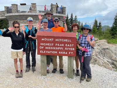
scout report:
I scouted this hike on Sunday, May 29, joined by Danny B., Lorraine B., Eva B. and Diane J. The hike begins with a 2-mile climb from the ranger station at Stepps Gap to the summit on the Old Mitchell Trail. The trails at Mt. Mitchell are notoriously eroded and this narrow trail lived up to its reputation with steep ups and downs, covered with rocks, roots, and after all the rain this past week, lots of water and mud. It took 2 hours to get to the summit where we stopped for a rest, lunch and enjoyed the views at the observation platform. We headed down the Mt. Mitchell Trail which overlaps with the MST. The footing started out better where we could see the great step work recently completed by CMC. But it then got more strenuous as we descended. This is a very popular trail and a lot of people passed us going in both directions. At the bottom, we headed back to the car on the wide Commissary Trail with its gradual uphill. I tracked the hike at 6.3 miles with a 1280 ft. ascent in 5 hours. Not too many wildflowers but the rhododendrons are starting to bloom. Hopefully they will be peaking the day of the hike. Waterproof boots are suggested, hiking poles are strongly recommended.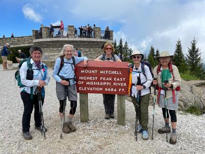
Sunday No. A2202-566-10457 Jun 19, 2022
Roans in Bloom 8:00 AM
Hike 7.6, Drive 130, 1500 ft. ascent, Rated B-B, at-mst, sb6k
Becky Smucker, 828-231-2198, bjsmucker@gmail.com
First Meeting Place: 160 Zillicoa St. (USFS parking lot) off Exit 25 of I-26.
Second Meeting Place: Ingles on US 19E at far right side (Burnsville) at 8:30 AM
A beautiful A.T. hike with some of WNC's finest views. Expect to see flame azaleas, rhododendrons and possibly Gray's lilies in bloom. From Carvers Gap we'll go north past Grassy Ridge Bald (6160 ft.) to a scenic overlook for lunch, then return to Carvers Gap by the same route. From here, we'll drive up to the gardens area (small fee to enter) and walk 1/2 mile to see the vista from Roan High Bluff (6287 ft.). This hike is #100 of the 100 Favorite Trails.
Topo(s): Bakersville,Carvers Gap
scout report:
Three of us scouted this magnificent hike on a brisk, clear morning. This was a little early in the season, so the gate to the west end wasn't open yet, but we scouted the eastern in-and-out, which is most of the hike. Only the earliest flowers were in bloom: dandelions, bluets, trout lilies, wood anemones, spring beauties, sweet white violets, and strawberries. This is not a long hike, but the footwork is challenging -- lots of steps and step-overs, and very rocky. We should be ready for peak crowds and unpredictable weather at this high elevation. Keep fingers crossed for rhodies in bloom and clear skies for unending views! Becky
hike report:
Whew, what a perfect day for this hike! Weather was cool and comfortable, and views were limited only by the curvature of the earth, I swear. We had 10 compatible hikers in the group (thanks!), including several new member and guests. There were a lot of people out there with us, but not so many as to cramp our style, and it was good to see so many young families and such a range of folks on the trail. Rhodies were past peak, but still beautiful in spots, along with flame azaleas and newly opened Grays lilies. A friendly ridgerunner was camped out at the prime lily spot to keep people on the trail. A spectacular hike! The group photo is courtesy of a guest, Paige, and a friendly passer-by. Becky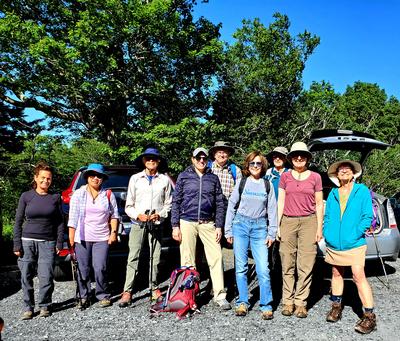
Saturday No. A2202-61-10466 Jun 25, 2022
Wilson Lick Ranger Station to Wayah Bald 8:30 AM
Hike 6.0, Drive 160, 1100 ft. ascent, Rated C-B, at-mst
Henry Kassell, 845-656-5528, hkassell@gmail.com
Only Meeting Place: Home Depot off Exit 44 of I-40. This shorter version of CMC hike #61 is #8 of the 100 Favorite Hikes. It will begin at the historic CCC-era Wilson Lick Ranger Station, hike up the A.T. to the Wayah Bald observation tower and return via the same route. This hike is #8 of the 100 Favorite Trails.
Topo(s): Wayah Bald
hike report:
Sunday No. A2202-228-10461 (canceled) Jun 26, 2022
Sunburst Campground to Mt. Hardy 8:30 AM
Hike 8.5, Drive 70, 3890 ft. ascent, Rated B-AA+, Wilderness hike, limited to ten hikers, contact leader for reservation. p400,sb6k
Les Love, 828-230-1861, lesrlove55@gmail.com and Catherine/Mrs Les Love, 828-658-1489, catmlove2@gmail.com
Only Meeting Place: Asheville Outlets parking lot behind Waffle House off Exit 33 of I-26. **Hike canceled due to no one signing up.** This strenuous variation of hike #228 will start at Sunburst Campground on NC 215 on the Green Mountain Trail. After an initial very steep mile, the climb slackens and we cross over Green Knob with spectacular views of Sam Knob, Shining Rock, and other peaks. Then it's on to the summit of Mt. Hardy at 6110 ft. We'll then get on the MST and take it to the parking area where the trail crosses NC 215. Car shuttle.
Topo(s): Sam Knob