ALL-DAY WEEKEND
Saturday No. A2201-893-10405 Jan 01, 2022
Green River Game Lands - West Side 9:15 AM
Hike 6.5, Drive 20, 1200 ft. ascent, Rated B-B,
Bruce Bente, 828-692-0116, cell 828-567-9443, bbente@bellsouth.net
Only Meeting Place: Cracker Barrel Restaurant off Exit 53 of I-26 in parking lot close to I-26. Driving distance from Asheville is 60 miles round trip. Join us for breakfast at Cracker Barrel at 8:00 AM, or at 9:15 AM in the parking lot to leave for our traditional New Year's Day hike in the Green River Game Lands. This year's hike will follow the shorter route on the west side of the Game Lands, but will still include lunch at the end of the Green River Cove trail by the big rocks in the Green River.
Topo(s): Cliffield Mtn
hike report:
On an unusually warm day that topped out about 70 degrees, 10 hikers met for breakfast and 13 to do the hike. Due to the threat of rain, a new route was hiked in order to avoid the Pulliam Creek crossing. Instead, we hiked down Bishop Branch and Pulliam Creek Trails, then back via Green River Cove, Bluff, Turkey Gut and Long Ridge Trails. Michael and Kathy and two teenaged relatives visiting Henry Kassell were ambitious and added the in-and-out hike down to the big rocks on the Green River. A surprise during the hike was seeing a few violets already in bloom, more than two months early.Sunday No. A2201-892-10406 Jan 02, 2022
NC 191 to Folk Art Center 9:00 AM
Hike 13.7, 2050 ft. ascent, Rated AA-AA, at-mst
Les Love, 828-230-1861, lesrlove55@gmail.com and Catherine/Mrs Les Love, 828-658-1489, catmlove2@gmail.com
Only Meeting Place: Back parking lot of Folk Art Center. Great workout hike for the winter over the rolling Biltmore section of the MST around Asheville. Lunch and warmup at Fresh Market. Car shuttle.
Topo(s): Asheville
hike report:
The weather really cooperated this year to stop the rain at 7 am and then not start snowing until after dark. It was the perfect window of opportunity for 8 of us to take on the 14 mile "Asheville corridor" MST, viewing all the tremendous work the Section Rovers Crew has been doing on almost all of these sections - steps, tread repair, water diversions, a new hand railing over one bridge where someone had fallen, and of course Mel's section that sets the standard of how good a trail can look. We all had an enjoyable lunch at the Fresh Market and even though it wasn't cold outside, it was still fun to come inside for a long hike and enjoy the treats they have to offer. We set a good pace, meeting at 9 am and finishing at the FAC around 4 pm. A fun day! LesSunday No. A2201-205-10407 (canceled) Jan 09, 2022
Waterrock Knob from Soco Gap 8:30 AM
Hike 9.0, 1950 ft. ascent, Rated B-A, at-mst, sb6k
Thomas Butler, 361-484-3381, butler.tom3381@gmail.com
Only Meeting Place: Maggie Valley Post Office. **Hike canceled due to high probability of rain.** Driving distance from Asheville is 77 mi. roundtrip. This hike starts from Soco Gap with an elevation of 4400 feet and heads steadily up to Waterrock Knob at close to 6400 feet. We will enjoy the view as we eat our lunch at the top. This section of the MST was completed by CMC in 2016. Expect to be impressed by the work that went into building this trail. We will visit Howard's Bridge, Piet's Place and some big oak, spruce and maple trees. We will return on the same trail.
Topo(s): Hazelwood
Saturday No. A2201-679-10408 Jan 15, 2022
Elk Pasture Gap - Mt. Pisgah via MST 10:00 AM
Hike 6.5, Drive 54, 1100 ft. ascent, Rated B-B, p400
Marcia Bromberg, 828-505-0471, cell 860-798-9905, mwbromberg@yahoo.com
Only Meeting Place: Home Depot off Exit 44 of I-40. This variation of CMC hike #679 (Elk Pasture Gap to Mt. Pisgah) takes advantage of the likely closure of the BRP. We'll access Elk Pasture Gap from scenic NC 151. From EPG we'll walk up the BRP to the Buck Springs tunnel, then use a rough trail on the side of the tunnel portal to get on top, enjoying great views of the valley below. Then a short path will take us to the Buck Springs Lodge parking lot and the MST. We'll take a side trip from the MST to the top of Mt. Pisgah (more great views), then follow the MST back down to EPG. If the BRP is open we'll do a shuttle hike from the Mt. Pisgah parking lot (again climbing Mt. Pisgah) to Big Ridge Overlook.
Topo(s): Dunsmore Mt
Sunday No. A2201-1-10416 (canceled) Jan 16, 2022
Case Camp - Seniard Ridge Loop 8:30 AM
Hike 8.0, Drive 80, 1800 ft. ascent, Rated B-A, p400,wc100
Michael Cornn, 828-458-1281, mwcornn@gmail.com and Kathy Cornn/Kyle, 828-458-1282, katherinenkyle@gmail.com
First Meeting Place: Asheville Outlets parking lot behind Waffle House off Exit 33 of I-26.
Second Meeting Place: Pisgah Forest Walmart parking (back of center aisles close to Taco Bell) at 9:00 AM
*Canceled due to snowstorm* This loop hike is scheduled for our coldest month to see 50-ft. frozen cascades along the closed Blue Ridge Parkway. We'll do a two-mile climb up to the MST and some gentle MST hiking before our lunch spot with great views of the mountains. After lunch, we'll hike downhill through beautiful woods on the Seniard Ridge Trail, passing two nice waterfalls along an old logging road. If Forest Road 475B is closed, we will have to walk to and from the trailhead, adding 1.7 miles to the hike. Please be advised that if you are not vaccinated, we will ask that you not carpool with the group.
Topo(s): Shining Rock
hike report:
Hike Cancelled because of snow.Sunday No. A2201-209-10418 Jan 23, 2022
Buckwheat Knob - Coontree Loop 8:30 AM
Hike 8.0, Drive 60, 2200 ft. ascent, Rated B-AA, p400
Marie Chamberlin, 678-492-6718, marie.m.chamberlin@gmail.com
First Meeting Place: Asheville Outlets parking lot behind Waffle House off Exit 33 of I-26.
Second Meeting Place: Pisgah Forest Walmart parking (back of center aisles close to Taco Bell) at 9:00 AM
From the trailhead at Coontree Picnic Area, we'll climb along beautiful Coontree Creek through open forest up to Bennett Gap and on to Buckwheat Knob for lunch, then return via the other segment of the Coontree loop. This is a moderate woodland hike with exceptional views from the ridgeline. This hike exceeds the requirement for hike #62 of the 100 Favorite Trails.
Topo(s): Shining Rock
hike report:
Eleven lively hikers joined me for this snowy hike. Snow was still on the trail after last weekend’s big snow. The trail is mostly an uphill climb, but generally quite gradual. As a group we elected to cut the hike a little short due to trail conditions, and instead of walking all the way to Buckwheat Knob we stopped for lunch at a scenic viewpoint and then headed back down to complete the loop. In places the trail was snow with a very crusty top, then could be slushy or even bare ground in places where the sun clearly had melted all the snow. There were a few slippery places and we were thankful for our poles. Low water at the stream crossings allowed us to walk through the water rather than attempt to negotiate the sketchy bridges. We completed the hike in about 4 hours, including a lunch stop of about half an hour. The hike began in the 20’s but gradually warmed up to the mid 40’s by the time we finished.scout report:
I scouted this hike with a friend on Jan. 13. Our hike began with temps in the 30’s but gradually rose to the 40’s by the end. And although it was completely overcast when we started hiking, the skies cleared somewhat and we saw some sunshine later in the day. This hike follows a generally uphill climb, crossing Coontree Creek several times with sketchy two-log bridges. The water level was so low that I was able to skip the bridges and walk across the water. The trail crosses a forest road and then continues uphill to the Knob. I particularly enjoyed walking along the ridgeline where you have views on either side. The hike also includes a fantastic view of Looking Glass Rock.Saturday No. A2201-101-10420 Jan 29, 2022
Lower Big Laurel Creek 9:30 AM
Hike 7.5, Drive 60, 350 ft. ascent, Rated B-C,
Judy Magura, 828-606-1490, quilter290@gmail.com and Jim Magura, 828-606-3989, jqs290@gmail.com
First Meeting Place: 160 Zillicoa St. (USFS parking lot) off Exit 25 of I-26.
Second Meeting Place: Corner of US 25/70 & NC 208 at 10:00 AM
Form carpools and meet leaders at second meeting place. Hike along a beautiful stream with whitewater, big rocks and surrounding high cliffs to the French Broad River. Interesting flora. Parts of the trail are rocky . Our lunch destination is the former sawmill town of Runion with its intriguing ruins. This hike is #43 of the 100 Favorite Trails.
Topo(s): Hot Springs
hike report:
We had to reschedule this hike from Saturday to Sunday due to a winter snowstorm and sub-freezing temperatures. But despite it all, we had a full crew (15) on Sunday to take in this hike with a very cold start. Fortunately, all hikers came equipped with micro spikes or similar foot gear to deal with the ice and snow on the trail. The trail completely covered in ice and snow and sub-freezing temperatures. The sun was out, but because we were in a valley along the river, we did not get much relief from the cold. Fortunately, by the time we went through Runon, conditions improved. We found a great spot in the sun by the river for lunch and a group photo. The return trip with rising temperatures was more enjoyable.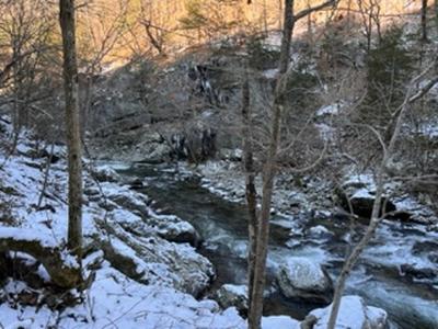
scout report:
Sunday No. A2201-847-10421 (canceled) Jan 30, 2022
Pinnacle 8:30 AM
Hike 8.0, Drive 90, 2500 ft. ascent, Rated B-AA,
Karen Schultz, 312-241-3329, schultz.karenj@gmail.com and Ken Scharmann, 847-772-4693, kennethscharmann@gmail.com
First Meeting Place: Home Depot off Exit 44 of I-40.
Second Meeting Place: Haywood County Rest Area 19500 Great Smoky Mtn. Expy. (US 23/74) Waynesville NC at 9:00 AM - but contact leader first.
*Hike canceled due to snow and icy conditions* This hike starts at the Fisher Creek Recreation Area near Sylva and ascends on the East Fork and Pinnacle Trails to see the great view from the Pinnacle. Our return will be via the West Fork Trail. This hike is #15 of the 100 Favorite Trails.
Topo(s): Sylva North
hike report:
Hike Cancelled due to weatherscout report:
scout report: On a beautiful winter day we scouted this hike with a fellow CMC hike leader. We started up the West Fork trail and then out to Pinnacle. The trail is steep in places, but mostly a gradual continuous uphill climb until the turn off to the Pinnacle. At Pinnacle there is a terrific place to have lunch with views in all directions. After lunch we retraced our steps back to the main trail and headed uphill again for a short distance before getting on the East Fork trail to head back to the parking lot. Portions of East Fork are extremely steep, so it was slow going at times (strongly suggest hiking poles). We spied many large trees that have fallen, but they have been cleared from the trail. We also encountered several icy places on the trails as it was about 25 degrees when we started but warmed up to about 50 by the afternoon. Total time about 5 hours including a half hour lunch break on the Pinnacle.Sunday No. A2201-332-10419 Feb 06, 2022
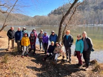
Foothills Trail: Upper and Lower Whitewater Falls 8:00 AM
Hike 11.6, Drive 105, 2400 ft. ascent, Rated A-AA, wc100
Donna Lanning, 828-606-7956, dblanning@bellsouth.net
First Meeting Place: Asheville Outlets parking lot behind Waffle House off Exit 33 of I-26.
Second Meeting Place: Pisgah Forest Walmart parking (back of center aisles close to Taco Bell) at 8:30 AM
Form carpools and meet leader at second meeting place. Come to hike in the warmer weather at the lower elevations! We’ll hike part of the Foothills Trail in NC and SC, featuring two of the region’s most stunning waterfalls. We will begin near the Upper Whitewater Falls parking lot and hike to the footbridge over the Thompson River. We’ll partially retrace our steps, then take the side trail to Lower Whitewater Falls, and finish at the Duke Power Co. Bad Creek parking lot. Short car shuttle.
Topo(s): Reid
scout report:
We scouted this hike on a chilly but partly cloudy day. What was so surprising was how much snow remained from the storm. While at home it had mostly melted it was still piled up on the roadside in this area but the roads were clear. The trails were still covered in snow on a lot of north-facing shaded areas, pretty for hiking but at times the trail was icy. The bridges we cross were also snow covered. The upper Whitewater falls were running somewhat low which isn’t surprising for the lack of rain but the lower falls were fuller...regardless, both are magnificent. It’s a very nice hike in the winter woods. Donnahike report:
Sunday, ten of us enjoyed chilly but sunny, clear skies as we walked this exceptional hike. We began at the Upper Whitewater Falls which were beautiful and running high. We then hiked down to the river where we did a mini rock (more like mini boulder) scramble over the fast running water because there was no ladder to assist. It must have been washed away in the storm last fall. After accomplishing that mini thrill, it was a mostly level walk along the river. We continued to the Thompson River bridge near where we had lunch. After climbing back out to a junction, we turned left to walk to the Lower Falls overlook. Those falls are farther away but are still an incredible sight. We then climbed back up to the junction and continued back to the cars. Lovely day with fun folks. ~11 miles, 2400 ft elevation gain in 6 hrsSaturday No. A2201-948-10413 Feb 12, 2022
Guion Farm P.L. #3 - Hickory Mtn. 9:00 AM
Hike 8.5, Drive 75, 1500 ft. ascent, Rated B-B,
Sarah Broughton, 828-564-3662, sarahebroughton@icloud.com
First Meeting Place: Asheville Outlets parking lot behind Waffle House off Exit 33 of I-26.
Second Meeting Place: Pisgah Forest Walmart parking (back of center aisles close to Taco Bell) at 9:30 AM
Form carpools and meet leader at second meeting place. We'll ascend Hickory Mountain, offering winter views of the adjacent ridgeline and enjoy a short break on the summit before descending along the creek on our return to the cars. Trails will include: Flatwoods, Shoal Creek, Rifle, Boundary, Hickory Mountain Rd., Hickory Mountain trail, Hooker Creek, White Pine, Thomas Cemetery, and Tarkiln Branch. There will be an option to hike an additional 1.5 miles to Wintergreen Falls if the group chooses.
Sunday No. A2201-589-10422 Feb 13, 2022
Shut-in Trail and Lake Powhatan loop 9:00 AM
Hike 11.4, Drive 10, 1500 ft. ascent, Rated A-B, at-mst, p400
Karen Schultz, 312-241-3329, schultz.karenj@gmail.com and Ken Scharmann, 847-772-4693, kennethscharmann@gmail.com
Only Meeting Place: Asheville Outlets parking lot behind Waffle House off Exit 33 of I-26. Contact Karen for reservations. This loop is a variation of CMC Hike #589. The first 5 miles of this hike are on the Shut-In section of the MST from NC 191 at the NC Arboretum to Sleepy Gap. Expect a steady climb to start, with some flatter ridges and climbs along the way. After a break at Sleepy Gap we will descend to our lunch spot at Lake Powhatan on a series of trails. The walk out on Old Bent Creek Gap Road through the NC Arboretum is broken up by forest trails along Bent Creek to the entrance of the Arboretum, and then a short walk to our cars. This hike is #75 of the 100 Favorite Trails. If you wish to carpool, you must be fully vaccinated against the COVID-19 virus.
Topo(s): Asheville
scout report:
We scouted this hike on a very cold day Wednesday, 1/26/22. The Shut In Trail is one of our favorites and the absence of leaves on the trees provided great views of the French Broad River and the icy Parkway. We were surprised at the amount of snow and ice still on the trail, since it has been over a week since the last significant snow fall. We were happy to have micro spikes to navigate most of the hike. We are hopeful that the warmer temperatures predicted for the next week or so will help rid the trails of the ice. This is hike #75 of the 100 Favorites. The hike gradually climbs the Shut In Trail about 1600 feet in elevation, until we get to Sleepy Gap, which is 2930 feet and the Crest of the Pisgah Ridge. We will stop for lunch here. We will then descend to Lake Powhatan via a group of nice gentle trails. We will use the Homestead Trail to leave the Lake area and then return to our cars on the Bent Creek Gap Trail and through the Arboretum. Our second meeting place will be the Bent Creek River Park where we will start our hike at 9:15 am. I encourage poles and if you have micro spikes, toss them in your pack.hike report:
We changed the only meeting place to be the Bent Creek River Park 11 people were not deterred by this late in the play change. This intrepid group continued to display the kind of grit for which the CMC is known. We scoffed at the steep climbs, winds blowing across the ridges, lunch was moved to the side of the mountain trail about 3 minutes passed Sleepy Gap and an unpredictable distance measured by Gaia to be 11.5 miles. All this accomplished with the incredible overall time of 5.5 hours. What a feat, what an accomplishment. We had one new member and one guest join us on the hike. They were strong hikers and contributed to the success of the hike.Sunday No. A2201-513-10423 Feb 20, 2022
Craven Gap to Rattlesnake Lodge 9:00 AM
Hike 8.8, 1600 ft. ascent, Rated B-A, at-mst
Lorraine Bernhardt, 828-699-8857, lsbernhardt50@gmail.com
Only Meeting Place: BRP Craven Gap parking lot at MM 377.4. This is a pleasant walk in the woods along the MST from Craven Gap to Rattlesnake Lodge with its ruins and CMC history. We will return via the same trail back to our cars at Craven Gap. This exceeds the requirement for hike #83 of the 100 Favorite Trails. Limit of 12 hikers.
Topo(s): Craggy Pinnacle
hike report:
We had a group of 10 meet up at Craven Gap to enjoy a chilly but sunny hike to Rattlesnake Lodge. There were already a few cars in the parking lot and we encountered a lot of hikers, especially after noon. We enjoyed long range views for most of the hike and the trail was great, except for one icy, downhill stretch. We all used our individual styles to traverse this patch. We had a pleasant lunch at RL and wound up back at the parking lot by 1:15.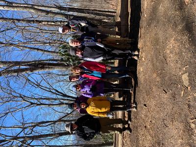
scout report:
Saturday No. A2201-324-10499 Feb 26, 2022
Bent Creek Loop #4 9:00 AM
Hike 3.5, Drive 5, 363 ft. ascent, Rated C-C, p400
Jan Onan, 828-606-5188, janonan59@gmail.com and Kate Fisher, 828-692-0161, cell: 828-606-9315, katewfisher@gmail.com
Only Meeting Place: Asheville Outlets parking lot behind Waffle House off Exit 33 of I-26. This is a newcomer's hike for those who are new to hiking. This is a shorter variation of the Bent Creek Loop, which is a pleasant, moderate loop hike in the Bent Creek Experimental Forest. We start on Hard Times trail and use parts of Wesley Branch Rd, Pine Tree Loop trail, South Ridge Rd., Deerfield Loop, Small Creek and Homestead trail. We will return to our cars via Hard Times trail.
Topo(s): Skyland
hike report:
It was a cloudy day in the 50s for this New comers introductory hike. Three new to CMC hikers enjoyed the views the leafless trees allowed and the varied terrain: paved roads, FS roads, well used trails and unmaintained trails. Each area allowed for a different experience. We started a bit late waiting for our 4th participant. Unfortunately we had no cell service at Hard Times trailhead, so did not know she was waiting at the wrong parking lot. We ended the hike at 12:45.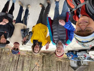
Sunday No. A2201-673-10417 (canceled) Feb 27, 2022
Coontree Loop to Pink Beds 8:00 AM
Hike 9.5, Drive 70, 2200 ft. ascent, Rated A-AA, p400
Thomas Butler, 361-484-3381, butler.tom3381@gmail.com
First Meeting Place: Asheville Outlets parking lot behind Waffle House off Exit 33 of I-26.
Second Meeting Place: Pisgah Forest Walmart parking (back of center aisles close to Taco Bell) at 8:30 AM
Form carpools and meet leader at the second meeting place. From the right branch of Coontree Loop we will climb up to and on Bennett Gap Trail to our lunch spot with a view of Looking Glass Rock. Proceeding on the Buckwheat Knob Trail to Club Gap, we will approach Rich Mountain and descend via Soapstone Ridge to Barnett Branch Trail. We will go over the Barnett Branch Boardwalk, built by CMC's Friday Pisgah crew, to the cars at the Pink Beds parking lot. Car shuttle.
Topo(s): Pisgah Forest
Sunday No. A2201-182-10415 Mar 06, 2022
Green River Cove to Pulliam Creek Trail 9:30 AM
Hike 6.2, Drive 75, 1000 ft. ascent, Rated B-C,
Carroll Koepplinger, 828-231-9444, cakoep29@gmail.com
First Meeting Place: Asheville Outlets parking lot behind Waffle House off Exit 33 of I-26.
Second Meeting Place: Cracker Barrel Restaurant off Exit 53 of I-26 in parking lot close to I-26 at 10:00 AM
Hike the Green River Cove Trail from the bridge to its end at the big rocks on the Green River, and return on same trail. The upper end of the hike is near the bottom of the "Narrows" section of the gorge that kayakers like to run. Expect a few early wildflowers and maybe even kayakers on the river. This hike is #72 of the 100 Favorite Trails.
Topo(s): Cliffield Mtn,Cliffield Mtn
hike report:
Sixteen hikers (12 ladies & 4 guys) left the trail head at 10:45 am for a pleasant day that started out with partly cloudy skies that turned into a mostly sunny day reaching temps of up to 80 degrees. With no leaves out yet, this led to a much warmer day than normal for early March. This trail at any time of the year is exposed to the sun. We enjoyed lunch on the rocks along the Green River. A number of Trilliums were seen with a couple on the verge of blossoming out. We had two "quiet times" while being close to the river of 20 minutes each, one on the way out and one on the return. Everyone felt the heat to an extent, so we took a ten minute shady rest break on the return. We arrived back at the trail head at 3:45 pm. Thanks to each of you for another great CMC hike!
scout report:
Bruce, Henry & I scouted this hike Monday, Feb. 24th. on a beautiful sunny day with temps in the low 50's. This trail is in very good condition with two or three short steep ascents. The CMC data base lists this hike at 6.2 mi. with 1,000' ascent. My GPS recorded the hike as 7.0 mi. with 1400' ascent. Those of you that plan on the hike should be aware of the new stats. CarrollSaturday No. A2201-383-10396 Mar 12, 2022
Fawn Lake P.L. #2 - Bridal Veil Falls 9:00 AM
Hike 7.9, Drive 38, 1400 ft. ascent, Rated B-B, wc100
Lorraine Bernhardt, 828-699-8857, lsbernhardt50@gmail.com
Only Meeting Place: Pisgah Forest Walmart parking (back of center aisles close to Taco Bell). Driving distance from Asheville is 85 mi. roundtrip. From the parking lot, we will take the Mine Mountain Trail, Shoals Trail, Corn Mill Shoals Trail to Bridal Veil Falls Road to view the falls. After the falls, we take the Corn Mill Shoals Trail, turn left onto Shelter Rock Trail, turn right onto Airstrip Trail, right on Conservation Road and right onto Fawn Lake Road back to our cars. This hike is #68 of the 100 Favorite Trails.
Topo(s): Standingstone Mtn
scout report:
This hike accesses several less traveled trails on the way to Bridal Veil Falls. Despite a parking lot that was filling up, we encountered no hikers until we approached Bridal Veil Falls, which made for a peaceful walk. There was low volume at the falls and both borders had dry patches. We again were lucky to have about 15 minutes with no others around and enjoyed our lunch on the rocks. We made a side trip up to Bridal Veil overlook en route but it wasn’t much of a view so won’t plan to add it on this hike. There are so many trails at DuPont, it was nice to explore some I haven’t hiked. Thanks to Donna for scouting this with me.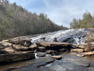
hike report:
This hike was rescheduled for the next day due to inclement weather. A little over half were still able to hike. As it remained cold, we also delayed the start time and were rewarded with a crisp, clear day with few people on the trail. We all chose rocks at the base of falls for lunch. We took a brief walk to the end of the airport strip to enjoy the long range views. Great day!
Sunday No. A2201-947-10427 Mar 13, 2022
Woods Mtn. via MST and Toms Creek 8:30 AM
Hike 9.0, Drive 75, 2700 ft. ascent, Rated B-AA,
Jim Reel, 828-443-2532, jimr57@yahoo.com and Melissa Gibson, 803-627-0867, MelJ.Gibson27@gmail.com
First Meeting Place: River Ridge Market Place behind CVS off Exit 53B of I-40.
Second Meeting Place: McDonald's at US 70 and US 221 Bypass in Marion at 9:00 AM
Note: First day of DST. Co-leader will be at first meeting place. Meet leader at second meeting place to set up the car shuttle. We will start out along Toms Creek and quickly gain elevation. After about a mile we intersect the MST. We will follow the MST and enjoy awesome winter views, including Lake Tahoma, as we ascend the mountain. At about four miles we turn off the MST and follow a faint trail to the summit of Woods Mtn. We will leave the summit of Woods Mtn. on an old trail along the ridgeline, then turn off the ridgeline and hike down thru the open forest as we follow parts of old roads and trails to the bottom of Toms Creek Falls. After enjoying the falls we will climb out from the top of the falls and around an old forest road back to our cars. NOTE: Toms Creek Falls is a tourist destination, but the tourists don’t come in and out of the falls from the direction that we will. Limit of 12 hikers.
hike report:
Sunday was an awesome beautiful day in the Grandfather Ranger District. It was sunny with no wind and 28 degrees. Perfect! Due to a variety of reasons, 7 hikers and one leader had to withdraw on Saturday, but the remaining 6 of us enjoyed an awesome day in the woods. We enjoyed nice winter views of the Black Mtns, Table Rock, Dobson Knob, Mackey Mtn, Lake James and Lake Tahoma as we hiked up to the summit mostly on ridgelines along the MST and Woods Mtn Trails. After lunch in the sun on the summit the fun part began. We followed the northeast ridge through, over and around rhododendron and downed tree limbs and a few trees before turning down into a large open deciduous forest with no trails. Eventually we come to a network of old, overgrown logging roads and paths connecting them. After a mile or so, we pop out of the woods just above the falls. The best part is over and we still haven't seen the falls!! We hike in and out of Toms Creek Falls from above. After a break for pictures at the falls, we hike out about a mile along a moss covered fire road. An awesome day in the woods! Another day in Paradise!!! Thanks to the hikers who showed up on a chilly Sunday morning!!
Saturday No. A2201-882-10412 Mar 19, 2022
Panthertown Valley Loop - East 8:30 AM
Hike 8.5, Drive 110, 1442 ft. ascent, Rated B-B, wc100
Judy Magura, 828-606-1490, quilter290@gmail.com and Jim Magura, 828-606-3989, jqs290@gmail.com
First Meeting Place: Asheville Outlets parking lot behind Waffle House off Exit 33 of I-26.
Second Meeting Place: Pisgah Forest Walmart parking (back of center aisles close to Taco Bell) at 9:00 AM
**This hike has been rescheduled from 2/19/22 due to icy trail conditions.** Form carpools and meet leader at second meeting place. This loop hike will take us to three waterfalls and one outstanding summit with beautiful views. We will begin on Mac's Gap Trail and hook up with Greenland Creek Trail to Greenland Creek Falls. We will take the Great Wall Trail to Granny Burrell Falls, then loop around to connect with Little Green Mountain to the summit and Tranquility Point. From there we return to our cars with a stop at Schoolhouse Falls. This meets the requirements for hike #14 of the 100 Favorite Trails.
Topo(s): Big Ridge,Lake Toxaway
hike report:
scout report:
Thanks to Sallye and Adrianne for scouting this hike with me. I have decided to move this hike from Saturday 2/19/22 to Saturday 3/19/22. Hopefully, the trails will be in better shape by then. I will leave the hike date for Wednesday on 2/23/22. The weather was beautiful on scout day. We found the trail close to the Greenland Creek Falls icy and covered with snow, but the waterfall was in great form with all the water. This water proved to be a problem later on in the hike. The Greenland Creek crossing is a rock hop, but the water was high. Ankle-high-water-proof boots along with polls are necessary to cross and keep the feet dry. The trail to Granny Burrell falls was water-logged and boggy so we didn't go there. The summit of Little Green had a lot of ice, so we walked on the edge in the grass. We had lunch there with another group of CMC hikers. After lunch, we hiked to Tranquility Point to enjoy the incredible views. Tranquility Point will be our lunch spot on hike day. We found ice on the trail down to Schoolhouse Falls. After visiting the falls, we tried to go to Warden's Falls; but the trail was under water. On hike day, we will vote on whether or not the group wants to try to get to Warden's Falls. All the requirements for the Favorite Hike #14 are met after visiting Schoolhouse Falls.
Sunday No. A2201-949-10424 Mar 20, 2022
Kephart Prong to Sweat Heifer Trail 8:00 AM
Hike 8.6, Drive 110, 2020 ft. ascent, Rated B-AA,
Mike Knies, 828-628-6712, knies06@att.net
First Meeting Place: Home Depot off Exit 44 of I-40.
Second Meeting Place: Maggie Valley Post Office at 8:30 AM - but contact leader first.
900M Learn about the logging operations before the GSMNP and the Civilian Conservation Corp. were established. We will explore an old logging and former CCC camp site close by the trailhead. After passing the Kephart Shelter in two miles, we will take the Sweat Heifer Trail two miles to another old RR logging camp slightly off the trail to explore the remains. We will return on the same path and have lunch at the shelter.
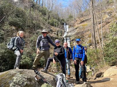
Saturday No. A2201-464-10414 Mar 26, 2022
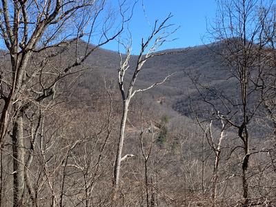
Balsam Gap (Walker Knob Overlook ) to Graybeard Overlook 9:00 AM
Hike 7.4, Drive 45, 2000 ft. ascent, Rated B-AA, at-mst
Danny Bernstein, 828-450-0747, dannyhiker@gmail.com
Only Meeting Place: Back parking lot of Folk Art Center. We will hike through a range of environments and landscapes on the MST, including rocky trail sections that require good footwear and hiking poles. This hike takes us from alpine vegetation through an old hemlock and lichen-covered oak forest, over an open blueberry bald with long-range views and finally through a lovely beech forest and sweeping native grasses to the Graybeard Overlook. We return to our cars on the same trail. This hike is #85 of the 100 Favorite Trails. CMC members only, no guests. You must be fully vaccinated against the COVID-19 virus.
Topo(s): Montreat
hike report:
The hike was changed to Craven Gap to Rattlesnake Lodge on the MST because the Blue Ridge Parkway was closed further up due to a landslide. I had to find a new hike quickly, as I kept checking the status of the parkway. Still seven hikers came and we all did #83 of the 100 FH of the Smokies and Blue Ridge. It was cold and very windy; we didn't stop much except for a short snack break on the way up and lunch at the Lodge. Thanks, all, for being flexible.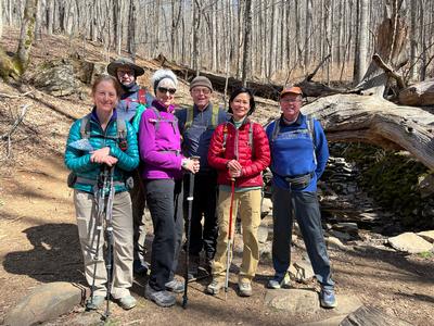
scout report:
The hike is on an high part of the MST - over 5,000 feet most of the day. Rocks, roots, blowdowns, twisted trees, wonderful views... It was slow going. And it was dry. The hike turned out to be 7.8 miles. But it's the terrain that is challenging. And if it's wet, even more challenging. Thanks to Karen L. for helping me scout it. It's hike #85 of the Favorite HIkes - so you have to do it.
Sunday No. A2201-355-10409 Mar 27, 2022
Fork Ridge Trail (at Carmen) to Devil Fork Gap 8:00 AM
Hike 11.3, Drive 95, 3100 ft. ascent, Rated A-AA+, at-mst
Tish Desjardins, 828-380-1452, desraylet@aol.com
First Meeting Place: 160 Zillicoa St. (USFS parking lot) off Exit 25 of I-26.
Second Meeting Place: Corner of US 25/70 & NC 208 at 8:45 AM
Form carpools and meet leader at second meeting place. This is a variation of CMC hike #355. We will reverse directions and go up the Fork Ridge Trail (at Carmen) and end at Devil Fork Gap. The hike follows along nine of the most scenic miles on the A.T., featuring two shelters, a historic grave site, and beautiful views from atop Big Butt. Car shuttle. Please bring enough cars for both trailheads so that hikers can be belted in safely.
Topo(s): Greystone
hike report:
Nice sunny day, but, windy and cold up there on the ridge --- layers and mittens were welcomed as fast as we could get them on! There were patches of snow on some of the shady spots. We had our lunch at Jerry's Cabin in order to get out of some of the wind. Unusually, we saw zero thru-hikers and the only people up there were us.