HALF-DAY SUNDAY
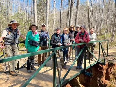
Sunday No. H2201-711-10379 (canceled) Jan 02, 2022
MST from US 25 to Visitors Center 1:00 PM
Hike 5.0, Drive 10, 400 ft. ascent, Rated C-C,
Bobbi Powers, 828-667-5419, bobbipowers23@gmail.com
Only Meeting Place: BRP Visitor Center at MM 383. Limit of 15 hikers, contact hike leader via email for reservations. This is a shorter version of Hike #711. This in-town part of the MST is a pleasant winter walk in the woods. Car shuttle.
Topo(s): Asheville,Oteen
Sunday No. H2201-280-10399 (canceled) Jan 09, 2022
North Slope and Art Loeb Trails 10:00 AM
Hike 7.1, Drive 40, 1375 ft. ascent, Rated B-B, p400
William Snow, 857-756-3815, billsnow123@gmail.com
First Meeting Place: Asheville Outlets parking lot behind Waffle House off Exit 33 of I-26.
Second Meeting Place: Pisgah Forest Walmart parking (back of center aisles close to Taco Bell) at 10:30 AM - but contact leader first.
Limit of 15 hikers, contact hike leader via email for reservations. Form carpools at first meeting place and meet hike leader at second meeting place. This is a moderate hike in the Pisgah National Forest. We will start at the Ranger Station and begin on the North Slope Trail, taking the connector to the Art Loeb Trail going counter-clockwise. We will then return from the Art Loeb Trail back to the Ranger Station.
Topo(s): Pisgah Forest
hike report:
This hike was canceled due to rain.scout report:
Four of us scouted this hike on Wednesday 5 January 2022. The weather was near perfect with few clouds. We hiked from the Ranger Station to the North Slope trail in a counter clockwise direction to the Art Loeb parking lot and back to the Ranger Station. The trails were in good shape except for the downed trees from the recent snow storm. There were 11 trees down with half on the Connector Trail between the North Slope and Art Loeb and the other half on the Art Loeb. We took time to clear many downed tree limbs and branches off the trail while photographing the downed trees.Sunday No. H2201-431-10380 (canceled) Jan 16, 2022
Chestnut Cove to MST to Sleepy Gap to Explorer Trail 12:00 PM
Hike 5.0, Drive 12, 900 ft. ascent, Rated C-C, p400
Dick Zimmerer, 828-785-9593, dd1zz@yahoo.com
Only Meeting Place: Asheville Outlets parking lot behind Waffle House off Exit 33 of I-26. Limit of 15 hikers, contact hike leader via email for reservations, informing us of vaccination status. Form carpools (if vaccinated) and drive to trailhead. (If not vaccinated, please still meet at the designated meeting place but plan to drive alone to the trailhead.) This hike off Bent Creek Gap Road follows a number of trails up to Chestnut Cove, then follows the MST to Sleepy Gap and back down into the Bent Creek area. At the beginning there will be a 750-foot climb that will take about an hour. Total hike time will be around 3 hours. There are many slippery rocks, roots and leaves on this trail, so poles are highly recommended.
Topo(s): Skyland
Sunday No. H2201-102-10400 Jan 23, 2022
Coontree Loop 11:00 AM
Hike 3.7, Drive 65, 1050 ft. ascent, Rated C-B, p400
Lee Belknap, 828-674-3631, rivergypsy@sprintmail.com
First Meeting Place: Asheville Outlets parking lot behind Waffle House off Exit 33 of I-26.
Second Meeting Place: Pisgah Forest Walmart parking (back of center aisles close to Taco Bell) at 11:30 AM - but contact leader first.
Limit of 15 hikers, contact hike leader via e-mail for reservations. This loop hike is partially along a lovely creek, with views from Coontree Mountain. Some steep areas. An option will be offered to hike an additional 2 miles to Bennett Gap and back, with an additional 200-ft. ascent.
Topo(s): Pisgah Forest
scout report:
The scout for this hike was eventful. There was a USFS crew cutting up the last fallen tree out of the trail and an NC wildlife official carrying an orphaned bear cub down the mountain. Outside of that the day was beautiful with the sound of running water on the way up and on the way down and winter views all along the ridge. The optional side trail to the overlook near Bennett Gap was a bit rougher with some up and down with some high steps. The overlook offered views between the back sides of Devils Courthouse and Shining Rocks with Black Balsam and Tenant Mountain between.Sunday No. H2201-948-10426 Jan 30, 2022
Guion Farm P.L. #3 - Hickory Mtn. 10:00 AM
Hike 5.0, Drive 75, 1000 ft. ascent, Rated C-C,
Sarah Broughton, 828-564-3662, sarahebroughton@icloud.com
Only Meeting Place: Pisgah Forest Walmart parking (back of center aisles close to Taco Bell). Limit of 15 hikers, contact hike leader via email for reservations. This shorter version of CMC hike #948 will ascend Hickory Mountain, with winter views of the adjacent ridgeline and enjoy a short break on the summit before descending along the creek on our return to the cars. Trails will include: Hickory Mtn. Rd, Hickory Mtn. Loop Trail, White Pine Trail and Buck Forest Rd.
Sunday No. H2201-168-10366 Feb 06, 2022
Pink Beds Loop 12:00 PM
Hike 5.0, Drive 80, 200 ft. ascent, Rated C-C, p400
Karen Lachow, 703-395-5879, heyk127@hotmail.com
First Meeting Place: Asheville Outlets parking lot behind Waffle House off Exit 33 of I-26.
Second Meeting Place: Pisgah Forest Walmart parking (back of center aisles close to Taco Bell) at 12:30 PM - but contact leader first.
Limit of 15 hikers. Contact hike leader via email for reservations. This regional favorite includes numerous boardwalks over and around beaver habitat through a beautiful forest.This is an easy and popular hike with negligible elevation change. This hike is #67 of the 100 Favorite Trails.
Topo(s): Shining Rock
scout report:
I scouted this hike on Dec. 28 with Kathy K. This is a very pleasant and easy going hike with almost no change in elevation. There hadn't been any rain in some time so the trails were very dry but you could see where there would be mud when wet. There are several creek crossings with good bridges all except in one spot that required a short rock hop. We hadn't brought poles with us but I wish I had them for that crossing.hike report:
Nine hikers, including 3 new members, joined me for what should have been an easy going, half-day afternoon hike on the Pink Beds Loop in Pisgah Forest. I'm going to call this the Comedy of Errors hike. First, just a mile in, one of the new hikers pulled a muscle on the back of her thigh. Fortunately, she and her husband drove by themselves so they turned around and left. Shortly after, my sunglasses fell to the ground and I proceeded to step on them. Then the sweep and another person got temporarily separated from the rest of the group. By the time we all united, it had gotten to be too late to do the whole hike so we cut across the Barnett Branch boardwalk to head back. When we got to the last creek crossing which should have been a rock hop, we found the water was much higher than usual from the recent rain and snow and it became a wet foot crossing. We did get in 4 miles and it was a beautiful sunny day with lots of good conversation. So, a nice afternoon in the end and we have a good story to tell. Unfortunately, the partial hike didn’t complete the requirement for the FH100 challenge.Sunday No. H2201-588-10402 Feb 13, 2022
Perry Cove and Bennett Gap Loop 10:00 AM
Hike 4.3, Drive 80, 1200 ft. ascent, Rated C-B, p400
William Snow, 857-756-3815, billsnow123@gmail.com
First Meeting Place: Asheville Outlets parking lot behind Waffle House off Exit 33 of I-26.
Second Meeting Place: Pisgah Forest Walmart parking (back of center aisles close to Taco Bell) at 10:30 AM - but contact leader first.
Limit of 15 hikers. Form carpools at first meeting place and meet hike leader at second meeting place. Contact hike leader via email for reservations. This moderate hike in the Pisgah National Forest is a modified version of hike #588. We will start from the horse stables and go to the left on Perry Cove Trail up to the Bennett Gap Trail, then go right to an overlook for lunch and return from Bennett Gap to the horse stables. We will have great views of Looking Glass Rock.
Topo(s): Shining Rock
scout report:
Leslie and I scouted this hike on Wednesday the 9th of February. The trails were in good condition except for one recent down tree on the Perry Cove trail which was passable. The weather was perfect without a cloud in the sky. We took our time cleaning up some of the downed branches from the recent bad weather, mostly on the Perry Cove trail. There were great views of Looking Glass Rock at the turn around point.hike report:
We had ten hikers, including 2 new members joining the hike. We met at the Pisgah Ranger Station and then carpooled from there to the Horse Stables. The parking lot at the Horse Stables has been enlarged and new gravel put down. It was cloudy and in the upper 30’s at the start of the hike, but it cleared up quickly and made it to the mid 40’s. When we reached Bennet Gap trail we went to the right to the overlook for lunch and had great views of Looking Glass rock and the surrounding area. Then we returned while passing the Coontree trail junctions and continued down to Avery Creek road and back to the Horse Stables. The hike was uneventful, and everyone enjoyed each other’s company and had a great time.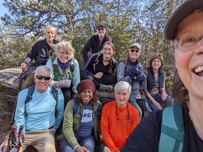
Sunday No. H2201-631-10378 Feb 20, 2022
High Falls P.L. #2 -Three Lakes plus Bridal Veil Falls 8:30 AM
Hike 6.0, Drive 70, 1500 ft. ascent, Rated C-B, wc100
Tom Lucha, 828-696-9117, cell 828-712-0736, luchat@bellsouth.net
First Meeting Place: Asheville Outlets parking lot behind Waffle House off Exit 33 of I-26.
Second Meeting Place: DuPont Forest High Falls parking lot at 9:15 AM
Limit of 15 hikers. Contact hike leader via email for reservations. Form carpools and meet leader at second meeting place. This hike is similar to CMC hike #631, and goes to three lakes (Dense, Alford and Julia) in DuPont Forest via Pitch Pine and Tree Lakes Trails plus Bridal Veil Falls. After a stop at the picnic table overlooking Lake Julia, we'll return via Conservation and Buck Forest Roads, and Covered Bridge Trail.
hike report:
After some last-minute cancellations, nine hikers met in the nearly empty Dupont parking lot on a 24-degree morning. After introductions, we briskly headed out toward Dupont's three lakes; Dense, Alford and Julia. By the time we reached the lakes the temperature had warmed considerably. I learned that most of the group had never done this hike and some had never been to Dupont Forest before. Ah, this gave me the opportunity to talk about the forest's history etc. One of our hikers besmirched little Lake Alford and declared it a pond. I think she was accurate. We enjoyed a quick visit to Bridal Veil Falls, which was very photo genic in the bright sun with lots of white water. We had lunch at the horse barn picnic tables where we were entertained by some young mountain bikers jumping a large boulder in this area. On our return trip we did a short side trip to High Falls. At our arrival at the PL, I was remined by the traffic waiting for parking spaces of why we started so early.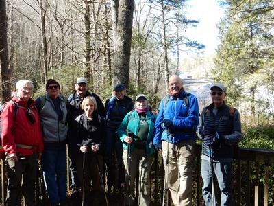
scout report:
I and seven friends hiked this trail the week after the "big snowfall". The heavily used trails near the PL and visitors center were icy and hazardous, but the remaining trails to and around the lakes were clear and dry. There was ice on the Bridal Veil Falls Road which should be clear/melted by the date of the hike. All three lakes took on a different appearance in the cold weather. Being ice covered and surrounded by snow, Lake Alford, was serene. ** The 1500 ft. ascent listed in the hike write up is overstated. By starting this hike at the Buck Forest PL instead of Hooker Falls PL, we estimated no more than 600 ft. ascent.Sunday No. H2201-46-10394 Feb 27, 2022
Bent Creek Loop #12 - MST side 12:30 PM
Hike 5.5, Drive 15, 1005 ft. ascent, Rated C-B,
Barbara Morgan, 828-460-7066, barbc129@gmail.com
Only Meeting Place: Asheville Outlets parking lot behind Waffle House off Exit 33 of I-26. Limit of 15 hikers. Contact hike leader via email for reservations. This loop hike will pass by Lake Powhatan and ascend to the Mountains-to-Sea Trail via the Sherman Stambaugh Trail. We will then descend on the Sleepy Gap, Explorer, and Pine Tree Trails back to the start.
Topo(s): Dunsmore Mt
scout report:
Lee S, Keiko, and Linda B helped me scout this hike on 2.9.22 - a beautiful February day. Hiking time about 3 hours, with 5 miles on the trail and about 900'elevation gain. It's a well graded counter-clockwise loop from Lake Powhatan to the MST at the parkway, along the MST to Sleepy Gap, and then down to near the start using a variety of Bent Creek trails. There's only one stream crossing, and it was short and easy; the others have bridges. Plan on a snack break at Sleepy Gap - if the parkway is still closed, it makes a really nice and quiet place to enjoy the view. By the time we were going downhill, the frozen ground had thawed, and we appreciated our poles! On the Feb 27 hike, we'll all need to meet at the Asheville Outlets parking and carpool & caravan from there as my planned parking area may be full on a Sunday afternoon and we may need to go to plan B. We were really impressed with the recent trail work on the Sleepy Gap trail. Thanks so much!hike report:
The weather prediction was showing a fairly high probability of rain for the afternoon, and most of those signed up chose to stay home and dry. But, two hikers decided to join me. One was a very experienced hiker but had just joined CMC, so this was her first club hike! The other was an also very experienced hiker from Brevard. We were happy to have no rain at all during the hike, although the "view" from Sleepy Gap was non-existent. The forecast had also scared off almost all the usual hikers/ runners/ and bikers in Bent Creek, so we had the trails to ourselves - very pleasant. Temp was about 45, and we took about 3 hours to do the 5 mile loop from Powhatan area, up the Stambaugh Trail to the MST, MST to Sleepy Gap, and several trails back to the start. A great day!Sunday No. H2201-347-10395 Mar 06, 2022
Twin Falls 10:00 AM
Hike 6.7, Drive 40, 1000 ft. ascent, Rated B-C, p400,wc100
William Snow, 857-756-3815, billsnow123@gmail.com
First Meeting Place: Asheville Outlets parking lot behind Waffle House off Exit 33 of I-26.
Second Meeting Place: Pisgah Forest Walmart parking (back of center aisles close to Taco Bell) at 10:30 AM - but contact leader first.
Limit of 15 hikers. Contact hike leader via email for reservations. Form carpools at first meeting place and meet hike leader at second meeting place. This is a moderate hike in the Pisgah National Forest. We will start from the horse stables and go to the right on Clawhammer Cove Trail and then Buckhorn Gap Trail to the falls (going counter-clockwise). We may come back on Avery Creek Trail, depending on the state of the bridges. We will view two nice waterfalls.
Topo(s): Pisgah Forest
scout report:
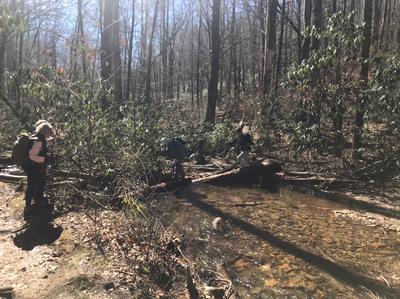
Five of us scouted this hike Tuesday March 1st, to see what condition the bridges were going over Avery Creek to confirm what route to do for the hike. I had to change the route since the very first bridge over Avery Creek was missing from Hurricane Fred. It only had a single log without a hand railing. We went back to the Buckhorn Gap trail and on out to where there are around 6-7 water crossings. The first crossing was a jumble of trees which was passable. There was another crossing with a jumble of logs along with some stones to hop over. The remaining bridges were passable, but not in their original condition. This route would be 6.7 miles and 890 ft. elevation. We returned on the Buckhorn Gap trail and took the Clawhammer Road down all the way to the Horse Stables. Originally, the Clawhammer Cove trail ended where the bridge was missing with only a single log without a hand railing that prevented us taking this route.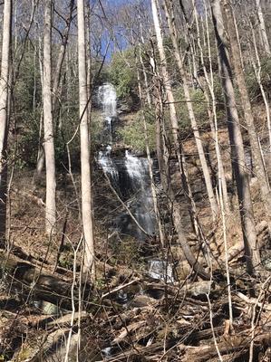
hike report:
We had seven hikers. We met at the Pisgah Ranger Station and then carpooled from there to the Horse Stables. It got up to 70 degrees and mostly sunny skies for a beautiful day. We hiked to the Buckhorn Gap trailhead instead of going on the Avery Creek trail since the bridge was out. We made it over the first two water crossings without bridges. The remaining partially rebuilt bridges were okay for crossing. We had a beautiful view of the waterfalls where we stopped for lunch. We continued with the Buckhorn Gap trail to the Clawhammer road to take it back to the Horse Stables.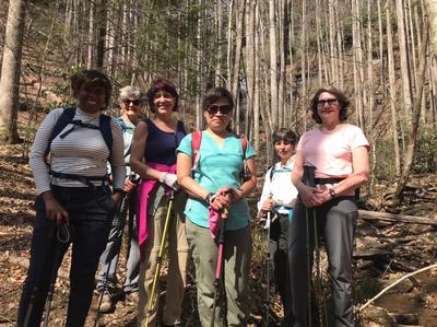
Sunday No. H2201-553-10367 Mar 13, 2022
Montreat Loop #4 - Lookout Rock 10:00 AM
Hike 5.0, Drive 40, 1000 ft. ascent, Rated C-C,
Jim Magura, 828-606-3989, jqs290@gmail.com and Judy Magura, 828-606-1490, quilter290@gmail.com
Only Meeting Place: Ingles off Exit 64 of I-40 (Black Mountain). Limit of 15 hikers. Contact hike leader via email for reservations.This moderate hike ascends the Lookout Trail over Lookout Rock and then follows the East Ridge Trail to Sourwood Gap. Return will be by the Toll Road, the Buck Gap Trail, and the Old Trestle Road to the Lookout Trail. After a moderately steep ascent and a short rock scramble, we will follow the ridge trail over several knobs and then return with an easy walk along the Toll and Trestle Roads. This hike is an extended version of #81 of the FH100 Challenge. CHECK YOUR CLOCKS...FIRST DAY OF DAYLIGHT SAVINGS TIME.
Topo(s): Montreat
hike report:
Given Saturday's snow storm, potential ice conditions and sub-freezing temperatures and potential treacherous conditions in Montreat. We cancel The Montreat Loop Hike and selected a local substitute half day hike at lower elevation (Folk Art Center to Lunch Rock) in Asheville. But following Lunch given the sunny conditions and rising temperatures and an enthusiastic hike group we continued up the climb .5 mile to a no-name peak, one of our favorite break spots on the MST from Cravens Gap to the Folk Art Center. Temperatures were a bit chilly in the morning but warmed up under a full sun and had a delightful day on the trail logging 6 plus miles for the half day hike. Lots of hikers and dogs on the trail made for some great conversations and fun. Bill Snow took a picture of a downed tree for maintenance follow up.
Sunday No. H2201-918-10398 Mar 20, 2022
Chestnut Ridge Heritage Center Wildflower Hike 10:00 AM
Hike 5.9, Drive 100, 1054 ft. ascent, Rated C-B,
Marcia Bromberg, 828-505-0471, cell 860-798-9905, mwbromberg@yahoo.com
First Meeting Place: Asheville Outlets parking lot behind Waffle House off Exit 33 of I-26.
Second Meeting Place: Cracker Barrel Restaurant off Exit 53 of I-26 in parking lot close to I-26 at 10:15 AM
Limit of 10 hikers, contact hike leader via email for reservations. This new spring hike offers the opportunity for early wildflower viewing. The 2.8 mile in/out trail near Landrum in South Carolina will take us up the south side of Squirrel Mountain, then down to the South Pacolet River. We understand that it is haven for trillium and other early spring wildflowers.
hike report:
Ten hikers took advantage of a picture perfect day to hike, what for most was a new hike, at Chestnut Ridge Heritage Preserve in South Carolina. As promised there were many wildflowers--18 different kinds--including one lonely trout lily pictured here. Thanks to Danny for our group picture!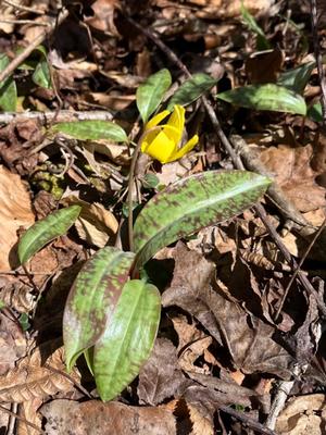
Sunday No. H2201-324-10369 Mar 27, 2022
Bent Creek Loop #4 11:00 AM
Hike 5.0, Drive 15, 600 ft. ascent, Rated C-C, p400
Carroll Koepplinger, 828-231-9444, cakoep29@gmail.com
Only Meeting Place: Asheville Outlets parking lot behind Waffle House off Exit 33 of I-26. Limit of 15 hikers. Contact hike leader via email for reservations. A pleasant, moderate loop hike in the Bent Creek Experimental Forest, starting at Hard Times Trailhead and using parts of Homestead Trail, Small Creek Trail, Deerfield Loop, Pine Tree Loop, South Ridge Rd., Sleepy Gap Trail, Explorer Loop, Pine Tree Loop and then along FS 479. There is a short, steep off-trail scramble in the middle of the hike. This hike is #74 of the 100 Favorite Trails.
Topo(s): Skyland
hike report:
This was a pleasant 5 mi. hike on excellent well-maintained trails in Bent Creek. We had a sunny day with temps getting into the low 50's towards the end of the hike. The windy conditions varied depending on the location at the time. We completed this casual hike in 3 hours including a short snack/lunch break midway in the hike. This hike is the first hike in a long time where the men outnumbered the ladies! 6 - 1 - Carroll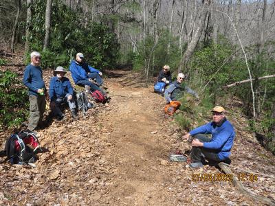
scout report:
I scouted this hike on a pleasant sunny day (Feb. 15). This is pleasant easy hike with about 700' elevation gain over 5.0 miles. The trail is in good condition with only a couple of areas that are very short steeper ascents. This hike has become one of my favorite (if not the favorite) hike in the Bent Creek area. I look forward to leading the hike. Carroll