ALL-DAY WEEKEND
Sunday No. A2001-209-4874 Jan 05, 2020
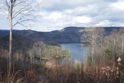
Buckwheat Knob - Coontree Loop 8:30 AM
Hike 8.0, Drive 70, 2200 ft. ascent, Rated B-AA, p400
Lorraine Bernhardt, 828-699-8857, lsbernhardt50@gmail.com
First Meeting Place: Asheville Outlets parking lot behind Waffle House off Exit 33 of I-26.
Second Meeting Place: Pisgah Forest Bi-Lo at 9:00 AM
Form carpools and meet leader at second meeting place. From the trailhead at Coontree Picnic Area, we'll climb along beautiful Coontree Creek through open forest up to Bennett Gap and on to Buckwheat Knob for lunch, then return via the other segment of the Coontree loop. A moderate woodland hike with exceptional views from the ridgeline.
Topo(s): Shining Rock
hike report:
This was a beautiful sunny day that started cool but became more comfortable. Nice winter views along the ridgeline with two scenic breaks for a snack and lunch. We had 14 enthusiastic hikers. It was a great way to start 2020!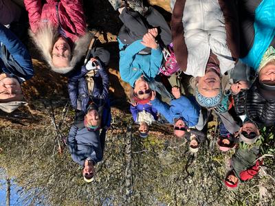
Saturday No. A2001-530-4866 Jan 11, 2020
Rice Pinnacle P.L. #1 - sunny side of Bent Creek 10:00 AM
Hike 7.0, Drive 10, 900 ft. ascent, Rated B-C, p400
Marcia Bromberg, 828-505-0471, cell 860-798-9905, mwbromberg@yahoo.com
Only Meeting Place: Asheville Outlets parking lot behind Waffle House off Exit 33 of I-26. This variation of hike #530 will be a 6 to 8 mile ramble on the sunny side of Bent Creek Road, with good views of Hominy Valley and Ingles Field. The exact route will depend on which roads and parking areas are accessible on this winter day.
Topo(s): Skyland
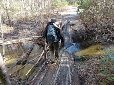
Sunday No. A2001-826-4868 Jan 12, 2020
Corn Mill Shoals P.L. #4 Cedar Rock 8:30 AM
Hike 9.8, Drive 90, 1300 ft. ascent, Rated A-B,
Michael Cornn, 828-458-1281, mwcornn@gmail.com and Kathy Cornn/Kyle, 828-458-1282, katherinenkyle@gmail.com
First Meeting Place: Asheville Outlets parking lot behind Waffle House off Exit 33 of I-26.
Second Meeting Place: Pisgah Forest Bi-Lo at 9:00 AM
This three-loop hike will explore a rock quarry, mountain vistas and river views.
Topo(s): Standingstone Mtn
hike report:
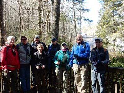
Fourteen of us hiked this series of figure eights on a sunny and warm January day in DuPont State Forest. We had to modify the hike because of heavy rains the night before the hike. The bridge crossing Little River after lunch on Cedar Rock was flooded as well as the trail past the bridge, according to hikers and bike riders we met on the trail, so we retraced part of our steps and saw a flooded Corn Shoals, added the Nooks Trail, which was less than a half mile loop, and then completed Burnt Mountain Trail loop before ending the hike at about 4 p.m. Several of us ate at Nine Mile in Asheville after the hike.
scout report:
Michael and I scouted our January hike December 1st, which turned out to be the perfect hiking day. The views were incredibly clear. The hike is a labyrinth in Dupont, but with well marked junctions. It’s a combination of various trails and includes a view of Corn Shoals, Cedar Rock and the old quarry. There were mountain bike riders on the trails, but overall there wasn’t a lot of traffic. We also saw a few deer in the distance on the last loop of the hike. We started at about 11 and were finished a little after 4. Afterwards we ate at Sora’s, so we’ll probably eat there again after the hike in January.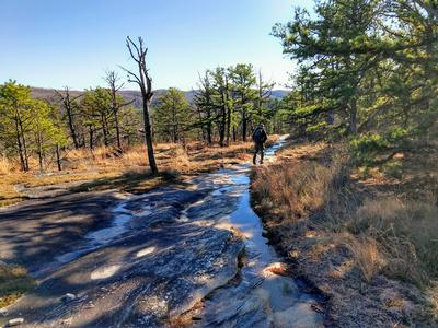
Sunday No. A2001-270-4895 Jan 19, 2020
Cedar Rock Mountain and John Rock 9:00 AM
Hike 8.0, Drive 80, 2000 ft. ascent, Rated B-AA, p400
Debby Jones, 404-731-3119, Djones715@aol.com
First Meeting Place: Asheville Outlets parking lot behind Waffle House off Exit 33 of I-26.
Second Meeting Place: Pisgah Forest Bi-Lo at 9:30 AM
Form carpools and meet leader at second meeting place. This trip features two of the spectacular bare rock faces in the Pisgah National Forest, with great views from both. Starting at the Fish Hatchery, we'll have our major climb up to Cat Gap and then on to Cedar Rock to enjoy the view during lunch. We'll return via John Rock.
Topo(s): Shining Rock
Saturday No. A2001-1-4867 Jan 25, 2020
Case Camp - Seniard Ridge Loop 8:30 AM
Hike 8.0, Drive 80, 1800 ft. ascent, Rated B-A, p400,wc100
Brenda Worley, 828-684-8656, cell 828-606-7297, bjdworley@gmail.com
First Meeting Place: Asheville Outlets parking lot behind Waffle House off Exit 33 of I-26.
Second Meeting Place: Pisgah Forest Bi-Lo at 9:00 AM
Form carpools and meet leader at second meeting place. This loop hike is scheduled for our coldest month to see 50-ft. frozen cascades along the closed Blue Ridge Parkway. We'll do a two-mile climb up to the MST and some gentle MST hiking before our lunch spot with great views of the mountains. After lunch, we'll hike downhill through beautiful woods on the Seniard Ridge Trail.
Topo(s): Shining Rock
hike report:
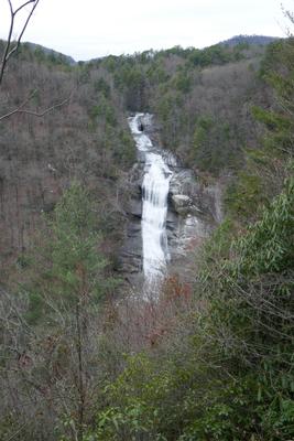
Six of us took advantage of this fine day to hike the varied trails and view the beautiful landmarks on this hike, two waterfalls, icicles on the rocks on the parkway, and great close-up views of Looking Glass Rock. The hike up the challenging Case Camp trail started us off with a good workout with it's 900' elevation gain in 1 and 1/2 miles. Then we entered the gentle MST from the parkway to just before Skinny Dip Falls where we reentered the parkway to view the medium crop of icicles on the rocky side of the parkway. After lunch on the guardrails, we started down Seniard Ridge Trail and ran into a very interesting trail blockage. It appeared a bolder had rolled down the ridge, hit one large tree which hit another tree and blocked the trail completely. We had to take a detour and had a little trouble getting back on the trail. The rest of the hike was as usual with a beautiful display of water at the two waterfalls and an uneventful hike back to our cars. The downed trees on the trail were reported to trail maintenance.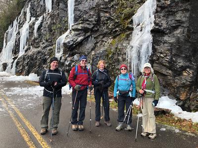
scout report:
Thanks to Debby for scouting this lovely hike with me. We started out on the trail at 9:05 and got back to the car at 2:10. The trail is in good shape but the first one and one-half miles is pretty much straight up with a 900' elevation gain. The rest of the trail is up and down until we reach the area on the parkway with the icicles. After that it is down hill until at the end when we climb up a short way back to the cars. Of course, there were no icicles but the waterfalls, Log Hollow and Logging Rd, were both beautiful and full of water due to the recent rains. It is possible that the gate on the access road will be closed which will require that we walk an additional .7 miles each way. My GPS recorded the hike at 7.83 miles with a 1960' climb. This is different from what is shown in the hike database. I will check it again during the hike before I make a change in the database.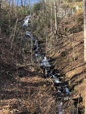
Sunday No. A2001-892-4875 Jan 26, 2020
NC 191 to Folk Art Center 9:00 AM
Hike 13.7, 2050 ft. ascent, Rated AA-AA, at-mst
Les Love, 828-230-1861, lesrlove55@gmail.com and Catherine/Mrs Les Love, 828-658-1489, catmlove2@gmail.com
Only Meeting Place: Back parking lot of Folk Art Center. Everyone had so much fun with this hike in previous years that we decided to do it again. Great workout hike for the winter over the rolling Biltmore section of the MST. Car shuttle.
Topo(s): Asheville
hike report:
It was a cold day early, but no snow or ice like we've had on this hike in previous years. 13 of us strolled over the gently rolling trail through the Biltmore section stopping for our much anticipated lunch at the Fresh Market half way through, taking the short access trail that leads you to that shopping center. A fun, different way to meet for lunch on a hike in their cozy cafe. None of us could believe we had done 14 miles at the end because of the cushy trail and the gentle slopes, meeting at 9am and ending at 4pm - the beauty of enjoying a great trail right here in Asheville. LesSunday No. A2001-518-4859 Feb 02, 2020
Five Waterfalls in S.C. 8:00 AM
Hike 8.5, Drive 170, 1500 ft. ascent, Rated B-B, wc100
Sallye Sanders, 208-550-2070, sallye_sanders@yahoo.com
First Meeting Place: Asheville Outlets parking lot behind Waffle House off Exit 33 of I-26.
Second Meeting Place: Pisgah Forest Bi-Lo at 8:30 AM
Form carpools and meet leader at second meeting place. Visit five great waterfalls in South Carolina, all on the Waterfall 100 Challenge: Spoonauger, King Creek, Yellow Branch, Issaqueena and Station Cove. All are in-and-out hikes, with 1-2 miles round trip each. Long drive and long day, but well worth it with waterfalls.
Topo(s): Tamassee
scout report:
The hikes to the waterfalls are on very popular and well maintained trails. All of the waterfalls are on the CMC challenge list.Sunday No. A2001-551-4880 Feb 09, 2020
Davidson Campground - Fish Hatchery via Cat Gap 8:00 AM
Hike 10.0, Drive 70, 2200 ft. ascent, Rated A-AA, p400,wc100
Donna Lanning, 828-606-7956, dblanning@bellsouth.net
First Meeting Place: Asheville Outlets parking lot behind Waffle House off Exit 33 of I-26.
Second Meeting Place: Pisgah Forest Bi-Lo at 8:30 AM
Form carpools and meet leader at second meeting place. This will be a moderately-paced hike on the Art Loeb Trail and via Cat Gap, with lunch atop Chestnut Knob. Car shuttle.
Topo(s): Pisgah Forest,Shining Rock
hike report:
Eleven hikers joined me on a beautiful, cold but clear day. We were all glad to be out in the sunshine and fresh air...haven’t been able to do much of that lately. The temp was 22 degrees when we started around 9:00 but was probably in the 40s by the time we finished up. Donna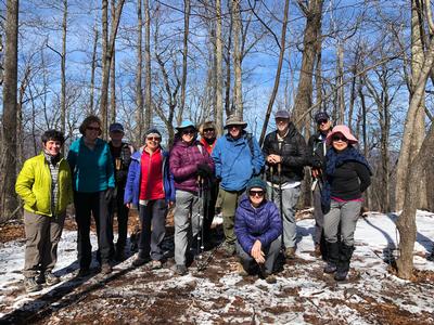
Saturday No. A2001-328-4872 Feb 15, 2020
Hardtimes P.L. #1 - Ingles Field 10:00 AM
Hike 7.5, Drive 10, 800 ft. ascent, Rated B-C, p400
Barbara Morgan, 828-460-7066, barbc129@gmail.com
Only Meeting Place: Asheville Outlets parking lot behind Waffle House off Exit 33 of I-26. Come out to enjoy a moderate hike in the Bent Creek area. From Hardtimes Trailhead, we’ll do a loop hike around Lake Powhatan, Explorer and Sidehill Trails, and descend past Ingles Field to our cars.
Topo(s): Dunsmore Mt
hike report:
There were 6 of us on this Bent Creek loop hike, and it was a great day. Started out chilly, but got into the mid 40's as the day went on. Clear blue skies, and we were pleasantly surprised to encounter very few bikers or hikers, considering it was a Saturday. We started at the Hardtimes Trailhead at 10:20, did our 6 mile loop, enjoyed lunch at the Lake Powhatan picnic area before finishing up at 1:20. Thanks, group, for a great hike, and welcome, Chuck, to your first CMC hike!
scout report:
With great help from Ken and Carol Deal, we’ve put together a viable route for Saturday’s hike in Bent Creek. The “official’ description was a bit sketchy to say the least, so we created something from the map that we partially scouted on Sunday, made adjustments to, and I re-scouted it just now. It involves the Homestead Trail, Pine Tree Loop, Explorer Trail, Lower Sidehill Trail, and the Campground Connector to make a 6 mile loop, with the only repetition being the return on Homestead Trail to avoid walking on the road. So, the hike is a bit shorter than the 7.5 miles in the writeup, and instead of 800’ ascent, it’s only 515’. It’s and interesting and relaxing hike, but with it being on a Saturday, we’ll need to be on the lookout for bikers. Also with it being on Saturday, the Hardtimes TH parking lot will be crowded, so please plan to meet at the Asheville Outlets meeting place behind Waffle House and carpool from there to minimize the number of cars we need to park.Sunday No. A2001-631-4882 Feb 16, 2020
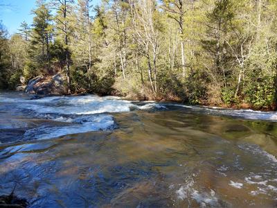
High Falls P.L. #2 - Triple, High, Bridal Veil & 2 lakes 8:30 AM
Hike 10.0, Drive 70, 1500 ft. ascent, Rated A-B, wc100
Susan Hutson, 336-406-9279, picassue48@gmail.com
First Meeting Place: Asheville Outlets parking lot behind Waffle House off Exit 33 of I-26.
Second Meeting Place: Pisgah Forest Bi-Lo at 9:00 AM
This hike goes to three of the best waterfalls and two lakes in DuPont Forest. We will go to Triple and High Falls and then to Lake Dense. After lunch at the lake, we'll use Conservation Rd. and cross the dam at Lake Julia. We'll hike to the beautiful Bridal Veil Falls, and then Lake Julia Rd. After a stop at the picnic tables overlooking the lake, we'll return via Conservation and Buck Forest Roads.
hike report:
Eighteen hikers went on this ramble in Dupont Forest to view three waterfalls. Due to recent rains, the falls were full and picture perfect. The hike was modified due to the closure of Chestnut Oak Road, but we still had a pleasant 9.5 mile hike with lunch by picturesque Lake Dense.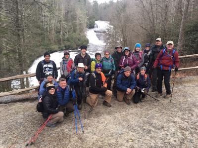
scout report:
Thanks to Brenda W and Daisy K for scouting this hike with me on Jan 24th. The falls were beautiful and rivers full of water. We had to modify the hike because Chestnut Oak Rd. is closed. We will start at the trail head for High Falls in the visitor center parking lot. After High Falls and Triple Falls, we will hike over the Covered Bridge then Follow Conservation Rd taking the Pitch Pine Trail to Three Lakes Trail. Lunch will be by one of the lakes before hiking to Bridal Veil Falls then returning via Conservation Rd and the Covered Bridge to the parking lot. The total distance will be about 8.5 miles.Sunday No. A2001-349-4878 Feb 23, 2020
Buck Spring Trail 8:00 AM
Hike 12.0, Drive 70, 1500 ft. ascent, Rated A-B, at-mst, p400
Sharon Smith, 704-877-7804, waltersharon204@gmail.com
First Meeting Place: Asheville Outlets parking lot behind Waffle House off Exit 33 of I-26.
Second Meeting Place: Pisgah Forest Bi-Lo at 8:30 AM
Form carpools and meet leader at second meeting place. This lovely hike gradually switchbacks up the mountain with a stronger grade at the finale. There are several easy creek crossings. After lunch, we will hike back downhill to our cars.
Topo(s): Cruso,Shining Rock
scout report:
Friday , Febuary 7th Judy M, Debbie J. , Sallie S. , and I scouted this hike. It was the day after we got 6 inches of rain, but I took my chances. There are 12 creek crossings! One way. We were able to cross all of them with no trouble. Well, boots got a little wet , but feet stayed dry. The trail is in great condition. You get your climb after about 4 and a half miles. Switchbacks make it not so bad. We encountered snow showers the whole day. But still had views at the top of Pisgah Inn. This is a great winter hike, views, good trail, and solitude.Sunday No. A2001-330-4869 Mar 01, 2020
Raven Cliff Falls 9:00 AM
Hike 8.0, Drive 95, 1600 ft. ascent, Rated B-A, wc100
Bruce Bente, 828-692-0116, cell 828-567-9443, bbente@bellsouth.net
First Meeting Place: Asheville Outlets parking lot behind Waffle House off Exit 33 of I-26.
Second Meeting Place: Pisgah Forest Bi-Lo at 9:30 AM
Form carpools and meet leader at second meeting place. We’ll do a pleasant walk to the pedestrian bridge over the top of a beautiful 250-ft. waterfall in Caesar’s Head State Park in S.C. The hike will follow the Raven Cliff Falls Trail and a portion of the Foothills Trail to the bridge and return on the same trails. $3 per person park fee.
Topo(s): Table Rock
hike report:
13 hikers enjoyed this moderate hike in cool sunny weather. We first stopped at the visitor center, and walked to the spectacular overlook from the top of Caesars Head. Next we drove 1 mile back to the trail parking lot, and hiked up-and-down trails to the bridge at the top of 250'-high Raven Cliff Falls, and then back to the other side to view the falls from the viewing platform on the other side of the valley. For info, the parking fee for Caesars Head St. Park is $3/person, and every S.C. park sets its own fees. I was told that the fee at Jones Gap St. Park is $5/person. Also, the parking lot for this hike fills up early, but additional parking is available along US 276 and an overflow parking lot 1/4 north of the main parking lot.Saturday No. A2001-909-4894 Mar 07, 2020
Asheville Camino del Norte Walk 9:00 AM
Hike 10.0, 500 ft. ascent, Rated A-C,
Danny Bernstein, 828-450-0747, dannyhiker@gmail.com
Only Meeting Place: Asheville Visitor Center (36 Montford Ave) lowest level of parking lot. Walk the Asheville Camino del Norte, a 10-mile easy walk on sidewalks and trails. See North Asheville, University of North Carolina at Asheville and the Botanical Gardens. Have a café con leche at the historic Grove Park Inn. The hike simulates a short day on the Camino. Wear good sneakers or low boots. Bring water, lunch and snacks. We'll stop for morning coffee but feel free to bring all your own food. For more information about the route, see www.ashevillecamino.org/about.html.
hike report:
Eight hikers showed up to walk the Camino Norte - a hike that was postponed from last week's snow. Three new people came - they were members of the Asheville Camino group. We discovered a new upcoming restaurant and several new and forgotten houses on Sunset Dr. The Grove Park Inn was as welcoming as ever. A great day for all. Danny
scout report:
Yesterday (Tuesday) I scouted this lovely hike through Asheville. The walk goes through Montford and North Asheville. There have been several changes to the sights. So if you've done this hike before, come on back. Make sure to have some water and a lunch. We'll stop at the Grove Park Inn for a morning coffee but we'll eat our own packed lunch.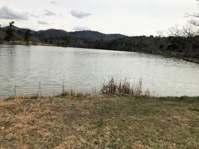
Sunday No. A2001-51-4883 Mar 08, 2020
White Oak Flats, Pounding Mill, Hickey Fork 9:00 AM
Hike 7.5, Drive 85, 1900 ft. ascent, Rated B-A,
Tish Desjardins, 828-380-1452, desraylet@aol.com
First Meeting Place: 160 Zillicoa St. (USFS parking lot) off Exit 25 of I-26.
Second Meeting Place: US 25/NC 208 intersection at 9:30 AM
Form carpools and meet leader at second meeting place. NOTE: First day of DST. Starting at the footbridge over Hickey Fork, we'll do a nice loop hike using three different trails and finishing on heavily-rebuilt Hickey Fork Rd.
Topo(s): White Rock
hike report:
Beautiful, mild, sunny day along these trails --- gorgeous distant views --- nice relaxing hike --- upper Hickey Falls was in full blast in its splendid various tiers --- wonderful job by CMC's Burnsville trail crew (John Whitehouse) where they eliminated 24 blowdowns this past Wednesday (and new waterbars) --- entertained at the end of the hike by a lone hiker with his long pipe (Swiss thing) per our request --- ran into folks I know that live on Hickey Fork road and they praised CMC for the trail work that they do!!!!! Fun day!!Saturday No. A2001-715-4881 Mar 14, 2020
Big Falls - Thompson River 9:30 AM
Hike 7.5, Drive 115, 1750 ft. ascent, Rated B-A, wc100
Daisy Teng Karasek, 828-505-2036, cell 408-887-3666, daisytk@yahoo.com
First Meeting Place: Asheville Outlets parking lot behind Waffle House off Exit 33 of I-26.
Second Meeting Place: Pisgah Forest Bi-Lo at 10:00 AM
This interesting new CMC hike will follow the Foothills Trail to and over the Thompson River bridge, then follow a manway for 1/2-mile upriver to the bottom of Big Falls.
Topo(s): Reid
hike report:
14 hikers joined me for this very pleasant hike to the Thompson River. The sky was overcast but we completed the hike without any rain materializing. We started out from the Bad Creek parking lot around 11:10 am and with only a couple brief stops, we arrived at the Thompson River at 12:50 for lunch. On the return, there was interest expressed for checking out the Lower Whitewater Falls Lookout. Twelve of us ended up completing the extra 1.8-mile roundtrip to the viewing platform that offered a spectacular view of the falls. With the extra mileage, the elevation gain for the hike was in the neighborhood of 1950 feet cumulatively. Everyone agreed that the extra effort was well worth it. We arrived back at the parking lot at 4:10 pm.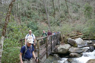
scout report:
Bruce and Sallye scouted this hike with me on Friday, 2/28, a fair weather day after a string of wet days. Ample parking and portable toilets at Bad Creek Trail Access. The spur trail from the trailhead to join with the Foothills Trail is 0.7 miles long and is in very good condition with sturdy bridges over the Whitewater River. The 2.7 miles of the Foothills Trail that take us to the Thompson River is in good shape as well with a couple downed trees that will not present any difficulty to the average hiker. After lunch by the river, we set off looking for the 'manway' to head up the east side of the river. Unfortunately, we soon found that it was a tough bush-whack with rhododendrons and brambles, and steep and unstable terrain slowing us down. After 45 minutes, Sallye and I had covered only half the distance of the 'manway'. I made the decision to turn around. I do not think that others would want to participate in a venture that carries significant risks of injury. We modified our return to include a walk along Musterground Road (a gravel road), an alternate way to return to the parking lot that provides some great views of Lake Jocassee. This will be a moderate hike of approximately 7 miles at a moderate pace. Sorry - we won't see Big Falls on this hike.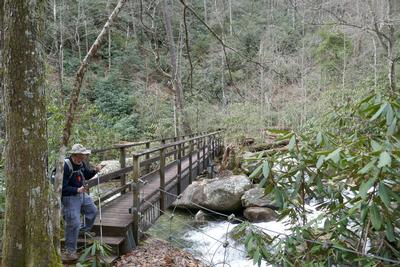
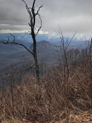
Sunday No. A2001-916-4898 Mar 15, 2020
Toms Creek to Woods Mountain 8:00 AM
Hike 8.0, Drive 80, 2600 ft. ascent, Rated B-AA,
Jim Reel, 828-443-2532, jimr57@yahoo.com
First Meeting Place: River Ridge Market Place behind CVS off Exit 53B of I-40.
Second Meeting Place: McDonald's at US 70 and US 221 Bypass in Marion at 8:30 AM
Form carpools and meet leader at second meeting place. This new CMC hike will explore the south side of Woods Mountain, beginning off Old Toms Creek Rd., hiking up to Woods Mountain. The return will be half via the same trail, and half on another trail.
hike report:
No one met Kathleen at our first meeting place. She met Paul and me and two new CMC hikers, Kerry and Chuck at McDonalds in Marion. Our new hikers stated they would prefer an off trail adventure to an out and back hike. We set a shuttle car and the adventure began. The five of us set out on a cloudy morning and followed the Woods Mtn horse trail to its junction with the MST. As we worked our way up the mountain, we enjoyed winter views of Table Rock, Hawksbill and Dobson Knob as well as Lake Tahoma and Lake James. After a nice lunch at the summit of Woods Mtn, we began our bushwhack down the ridgeline on our newly discovered route off the mountain. About 3/4 mile down the ridgeline, we saw an old roadbed we had not noticed a couple of weeks earlier. After a little discussion among the group, we decided to follow this old roadbed and see if it connected with our planned route. Sure enough. in a little while we were back on our planned bushwhack route and have now discovered an easier route to follow when bushwhacking up the mountain. I will lead this hike from now on on our new route. After the hike, Kerry and Chuck said they look forward to this kind of hikes in the future. This will be another new hike for CMC ! AWESOME! Thanks to Kathleen Hannigan and Paul Benson for helping me scout the mountains of McDowell County to create new hikes for CMC. Thanks to Kerry and Chuck for their sense of adventure! Photos courtesy of Paul Benson and Chuck Thrift.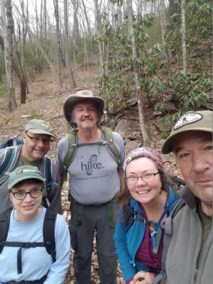
Sunday No. A2001-480-4830 Mar 22, 2020
Buck Spring to US 276 via Barnett Branch Trail 8:00 AM
Hike 11.9, Drive 70, 2000 ft. ascent, Rated A-AA, p400
Sarah Broughton, 828-564-3662, sarahebroughton@icloud.com
First Meeting Place: Asheville Outlets parking lot behind Waffle House off Exit 33 of I-26.
Second Meeting Place: Pisgah Forest Bi-Lo at 8:30 AM
Form carpools and meet leader at second meeting place. This strenuous hike will start at the Buck Spring Trailhead on US 276 and hike down to the maintenance yard via a series of trails. It will feature great views from Clawhammer and Black Mountains along the way. Car shuttle.
Topo(s): Shining Rock
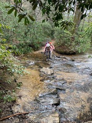
Saturday No. A2001-364-4879 Mar 28, 2020
Buckhorn Gap and Club Gap Loop 8:00 AM
Hike 10.5, Drive 80, 1320 ft. ascent, Rated A-B, p400
Judy Magura, 828-606-1490, quilter290@gmail.com and Jim Magura, 828-606-3989, jqs290@gmail.com
First Meeting Place: Asheville Outlets parking lot behind Waffle House off Exit 33 of I-26.
Second Meeting Place: Pisgah Forest Bi-Lo at 8:30 AM
This will be a loop with beautiful early spring views. We will begin from the Pink Beds parking area to the gauging station, with a rock-hop crossing of the S. Mills River (dry unless there has been heavy rain), then over the S. Mills and Buckhorn Gap Trails to Buckhorn Gap for lunch at the shelter. Next we’ll follow the Black Mtn. Trail to Club Gap and back to our cars.
Topo(s): Pisgah Forest,Shining Rock
scout report:
I had plenty of company on this scout hike and I really appreciated the good friends that came with me on a just OK weather day. There is one stream crossing, so wear waterproof boots, just in case you slip off one of the rock hops. This is a fairly moderate hike and the trails are in good condition. We will proceed on this circular route in a clockwise direction from Pink Beds Parking Lot and gently climb up to Buckhorn Gap. We will have one strenuous climb up to Soapstone Ridge, about 450 feet vertical and then follow the Ridge Line down and descend to Club Gap. We will have some nice views along the ridge line.
Sunday No. A2001-782-4876 Mar 29, 2020
Thomas Divide - Mingus Mill 8:00 AM
Hike 11.5, Drive 125, 1400 ft. ascent, Rated A-B,
Mike Knies, 828-628-6712, knies06@att.net
First Meeting Place: Home Depot off Exit 44 of I-40.
Second Meeting Place: Maggie Valley Post Office at 8:30 AM - but contact leader first.
A scenic early spring hike on the Thomas Divide, Newton Bald and Mingus Creek Trails. Should be some early spring flowers along the way. Note: 4000 ft. descent. Car shuttle.
Topo(s): Clingmans Dome,Smokemont