ALL-DAY WEEKEND
Tuesday No. A1901-893-4596 Jan 01, 2019
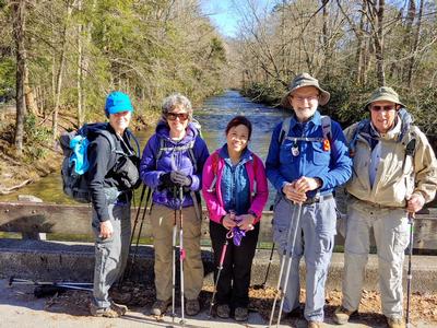
Green River Game Lands - West Side 7:30 AM
Hike 6.5, Drive 60, 1200 ft. ascent, Rated B-B,
Bruce Bente, 828-692-0116, cell 828-567-9443, bbente@bellsouth.net
First Meeting Place: Toys-R-Us on NC 191 across from Asheville Outlets.
Second Meeting Place: Cracker Barrel Restaurant off Exit 53 of I-26 in parking lot close to I-26 at 9:15 AM
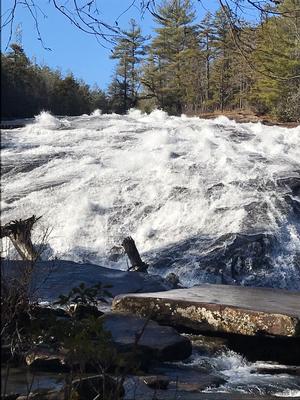
Form carpools and meet leader at second meeting place. After breakfast at Cracker Barrel, we'll leave at 9:15 AM and hike our traditional New Year's Day hike in the Green River Game Lands. This year's hike will follow a different route, which will be shorter but will still include lunch at the end of the Green River Cove trail by the big rocks in the Green River.
Topo(s): Cliffield Mtn
Sunday No. A1901-847-4654 Jan 06, 2019
Pinnacle 9:00 AM
Hike 8.0, Drive 125, 1900 ft. ascent, Rated B-A,
Brent Martin, 828-524-7400, alarkaexpeditions@gmail.com
First Meeting Place: Home Depot off Exit 44 of I-40.
Second Meeting Place: end of Fisher Creek Rd., off MM 85 of US 23/74 at 9:45 AM
Form carpools, and meet leader at second meeting place. This hike is from the Fisher Creek Recreation Area near Sylva. We will ascend on the East Fork and Pinnacle Trails to see the great view from the Pinnacle. Our return will be via the West Fork Trail.
Topo(s): Sylva North
Saturday No. A1901-499-4606 Jan 12, 2019
Greenways Around Asheville 10:00 AM
Hike 7.0, 100 ft. ascent, Rated B-C,
Marcia Bromberg, 828-505-0471, cell 860-798-9905, mwbromberg@yahoo.com
Only Meeting Place: Parking lot on Craven St. just north of New Belgium Brewery (west side of river). We will hike current and future greenways along the French Broad River, learning along the way about plans for a county-wide greenway system. Our exact route will depend on greenway construction completed and in process at the time of the hike. For those who are interested, we'll end with a beer at the New Belgium Liquid Center.
Topo(s): Asheville
hike report:
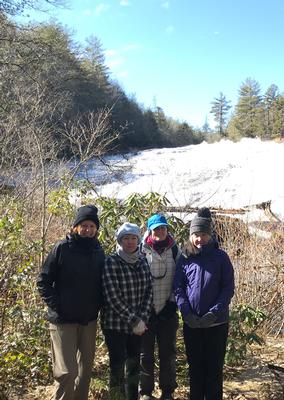
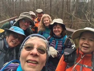
It was a chilly, cloudy day but 7 people joined me to walk and learn more about current and future greenways in Asheville. We started in Malvern Hills at the site of the old Sulpher Springs and ended up in New Belgium with a side stop for lunch and warm-up at Homegrown along the Carrier Park greenway. The picture was taken as we entered the Hominy Creek Greenway.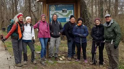
Sunday No. A1901-892-4610 Jan 13, 2019
NC 191 to Folk Art Center 9:00 AM
Hike 13.7, 2050 ft. ascent, Rated AA-AA, at-mst
Les Love, 828-230-1861, lesrlove55@gmail.com and Catherine/Mrs Les Love, 828-658-1489, catmlove2@gmail.com
Only Meeting Place: Back parking lot of Folk Art Center. Everyone had so much fun with this hike last year that Les and Catherine decided to do it again. Great workout hike for the winter over the rolling Biltmore section of the MST. Car shuttle.
Topo(s): Asheville
hike report:
Catherine couldn't make the hike due to a leg injury, but four of us showed up in spite of the forecast winter storm. There was lots of beautiful rime ice on the trees, but the temperature soon eased above freezing, so we were soggy and excited to get to our cozy lunch spot, the cafe in the Fresh Market on Hendersonville Road. After an hour of warmth and dry, we struck back out, but the ice had all fallen and it was an enjoyable walk on the undulating trail to the Folk Art Center. 14.4 miles in 5.5 hours - Daisy set a great pace! Les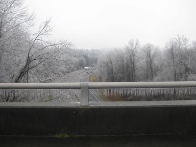
Sunday No. A1901-383-4655 Jan 20, 2019
Fawn Lake P.L. #2 8:30 AM
Hike 7.9, Drive 80, 1400 ft. ascent, Rated B-B, wc100
Lorraine Bernhardt, 828-699-8857, lsbernhardt50@gmail.com
First Meeting Place: Toys-R-Us on NC 191 across from Asheville Outlets.
Second Meeting Place: Pisgah Forest Bi-Lo at 9:00 AM
Form carpools and meet leader at second meeting place. Have you hiked the Reasonover Creek Trail recently? The trail is improved and wet creek crossings are no longer necessary. Here is an opportunity to hike to two lakes, Lake Julia and Fawn Lake, and beautiful Bridal Veil Falls.
Topo(s): Standingstone Mtn
scout report:
This is a beautiful hike! Easy stroll on a nice trail with rewarding views of two lakes and Bridal Veil Falls. We did have one lengthy stream crossing but our challenge was a short crossing with the rocks covered in water from recent heavy rain. After considering all options, we cautiously tested the water and decided to walk across barefoot. So do consider poles and a towel if the high water persists! We enjoyed lunch at the falls. We started around 9:20 and finished shortly after 2. Thanks to Bobbi and Donna for scouting this with me.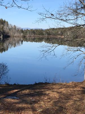
hike report:
A small group of four were able to get out of their neighborhoods and brave the blustery weather. The gray skies gave way to a sunny day. The water level was higher than on the scout hike, necessitating wading through knee deep water on a wet crossing. Eventually feeling returned to all feet! After lunch at Bridal Veil Falls, it was a very pleasant hike back to the parking lot as the wind calmed. Hike began at 9:45 and ended 2:15.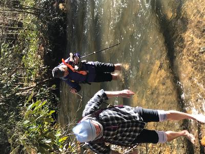
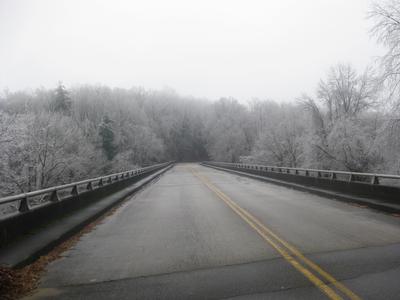
Saturday No. A1901-280-4651 Jan 26, 2019
North Slope and Art Loeb Trails 9:00 AM
Hike 7.5, Drive 60, 1600 ft. ascent, Rated B-A, p400
Becky Smucker, 828-231-2198, bjsmucker@gmail.com
First Meeting Place: Toys-R-Us on NC 191 across from Asheville Outlets.
Second Meeting Place: Pisgah Forest Bi-Lo at 9:30 AM
We start at the Davidson River Campground and ascend on the Art Loeb Trail to the North Slope Connector. We'll eat lunch at the intersection before we start down the connector to the North Slope Trail, ending with a lovely, easy stroll along the river to the cars.
Topo(s): Pisgah Forest
hike report:
What a beautiful January day we had for this hike! The sky was blue and sunny, and the air was brisk but not too breezy. We hiked up the Art Loeb Trail on Shut-in Ridge mostly in the sun and warmed up fast. Lunch was in the sun at the high point of the hike just before the intersection with the downhill North Slope Connector. The mile and a half along the Davison River had a few icy spots, but was also a really pleasant way to end the day, with the clear, full river on our left and mossy rock faces along the old road on our right. Thanks to Elaine Tennan for the bridge photo.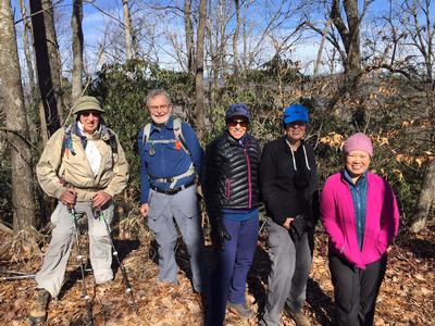
scout report:
This will be a beautiful January hike as long as there's not a lot of ice on the ground. Watch for Breaking News just in case. The hike isn't real long, but since much of it is pretty level, that leaves the rest of it with some good stiff ups along the Shut-In Ridge before lunch, and some steep down on the Connector Trail after lunch. We will be taking what's called on the attached topo the "Alternate Route" that follows along the river the last couple of miles on the North Slope Trail. See you there. BeckySunday No. A1901-634-4608 Jan 27, 2019
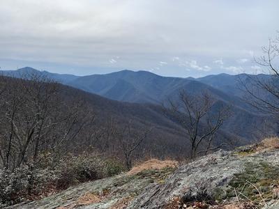
High Top Tower Site 8:30 AM
Hike 9.0, Drive 65, 1900 ft. ascent, Rated B-A, Wilderness hike, limited to ten hikers, contact leader for reservation. p400
Jim Magura, 828-606-3989, jqs290@gmail.com
Only Meeting Place: Home Depot off Exit 44 of I-40. This hike was a longtime favorite of the Boy Scouts at Camp Daniel Boone years ago. From the camp we will ascend to High Top with its excellent views and then follow the Fork Mtn. ridge before descending to the rushing Little East Fork of the Pigeon River. Car shuttle.
Topo(s): Shining Rock
scout report:
This will be our fourth trip up to High Top in the past six months. It has quickly become one of our favorite hikes. Fabulous winter views and a great trail are in store for the ten hikers that accompany us on this wilderness hike. The hike comes in at 8.3 miles and there is some elevation involved, but the views and the ridge trail are worth the effort. We are really looking forward to the winter views and we are keeping our fingers crossed that we will not be disappointed with poor weather conditions. If conditions are reasonably good we will make a short ascent to the old fire tower location at the pinnacle of High Top. Otherwise we will enjoy our lunch just below the peak. We will Follow the ridge line for about two miles and then descend on an overgrown fire road, with some down trees and brush to the East Fork of the Pigeon River. Some over and under bushwhack work will be required on the descent, but not severe.hike report:
The High Top Tower Hike definitely was not a boring winter outing! . We began the hike to High Top in sub-freezing temperatures (hat gloves and glove warmers) at 9:15am on the 27th of January as scheduled. The good news was that everyone (9 dedicated hikers) were in great spirts and looking forward to the hike. Following a 1900 foot climb, we reached the Fork Mountain trail junction along the ridge line in warming conditions with the promise of a great day ahead. Half the group rested on a nearby rock to take in the view looking west (photo) at the Middle Prong Wilderness and the balance went up to the top to the site of the former Fire Tower. Returning to the rock to also enjoy lunch, we quickly realized that the temperature was dropping rapidly as a cold front was moving in. Gloves and hats quickly went back on to deal with the dropping temperatures. With some haste we took a group photo and proceeded to hike across the Fork Mountain Ridge. We still had seven miles to go. We arrived at Birdstand Mountain 1.5 hours later and took a well-earned rest. The eastern side of Fork Mountain still at 5100 feet gave us some relief from the plunging temperatures. We then followed an overgrown logging road back down to the scout camp and earned our exercise points for the day. We arrived at our cars at 4:15 and recorded a distance of 9.2 miles and 3100 feet of elevation gain.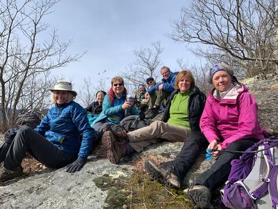
Sunday No. A1901-888-4665 Feb 03, 2019
Asheville Camino Walk 9:00 AM
Hike 16.0, 500 ft. ascent, Rated AA-C,
Danny Bernstein, 828-450-0747, dannyhiker@gmail.com
Only Meeting Place: Asheville Visitor Center 36 Montford Ave. lowest level of parking lot. Hike through several Asheville neighborhoods and greenways, on bridges and past waterways. See how various parts of Asheville are connected. You're welcome to leave at any time, but you'll be surprised at how comfortable this walk will be. This hike simulates a day on the Camino de Santiago in northern Spain. Bring water and food. We'll stop for morning coffee (no time for a full breakfast), lunch and afternoon snacks, but feel free to bring all your own food. Joint hike with the Asheville Chapter of the American Pilgrims on the Camino. For more information about the route, see www.ashevillecamino.org/about.html.
Topo(s): Asheville
hike report:
Wonderful hike through Asheville. 34 hikers started the 16-mile hike. People peeled off little by little. After lunch, 15 hikers tackled the hill taking us to Beaucatcher Mountain. At the end, five hikers stayed with me as we went into the Basilica of St. Lawrence. Friendships, connections, laughter and exercise were the result of this hike. Thanks all for coming. I appreciated all of you, no matter how long you stayed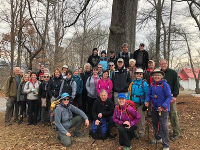
scout report:
I scouted this walk with the AVL Camino group. The walk takes you through the RAD district, W. AVL, to Henrietta's Poultry shop, and unto several greenways. After lunch, there's a short but very steep section, as we climb from Mission Hospital to the Beaucatcher area. We'll take it slow. Bring your water and snacks and dress like you're going on an all-day hike. Wear low boots - your feet will get muddy. Rain or shine. At the end, we stop for ice cream downtown and go to the Basilica before heading back to the Visitor Center.
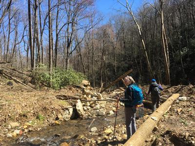
Saturday No. A1901-632-4597 Feb 09, 2019
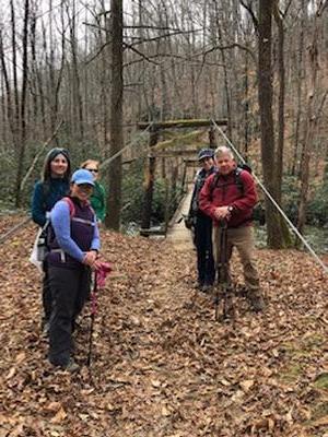
Cantrell Lodge History Hike 10:00 AM
Hike 8.5, Drive 55, 700 ft. ascent, Rated B-C, p400
Barbara Morgan, 828-460-7066, barbc129@gmail.com
First Meeting Place: Toys-R-Us on NC 191 across from Asheville Outlets.
Second Meeting Place: Ingles on NC 191/280 in front of gas pumps (Mills River) at 10:15 AM
This in-and-out hike begins at the Turkey Pen parking area and follows the South Mills River Trail to the Cantrell Lodge, following an old logging railroad grade. On the way, we'll cross three pedestrian bridges and see a couple of unusual Carsonite signs. We'll learn more about the history of this historic lodge and area.
Topo(s): Pisgah Forest
hike report:
Seven of us had a great day hiking along the South Mills River Trail from the Turkeypen parking to the site of the Cantrell Creek Lodge where the chimney still stands. The lodge was built in "Black Forest" style in the 1890s for Schenck's forest rangers to use in working with George Vanderbilt's Biltmore Forest. The actual lodge was moved to the Cradle of Forestry in 1979. Google "Cradle of Forestry" to see a photo, and plan a trip there if you're interested! It was a very congenial group, and I think we all enjoyed the relative ease of this hike in the warm sunshine. Thank you all!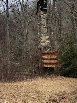
scout report:
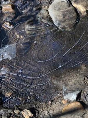
Jan and Kevin Onan (and pooch Sophie) helped me scout this hike on a lovely, warm, sunny January day. The hike begins at the Turkeypen informational sign and winds its way up South Mills River to the site of the 1890’s Black Forest style lodge built for Dr. Schenck’s forestry school he ran for George Vanderbilt. All that remains onsite is the chimney, but the lodge itself was relocated to the Cradle of Forestry up hwy 276. The in and out hike is gentle, climbing only 880’ over the route to the lodge, with a total round trip distance of about 8.5 miles. There are several crossings, but the first three are on suspension bridges and the last on a stout log with a handrail. Depending on temperatures, there may be some mud, but it’s winter, right? The drive in on the mostly one lane road wasn’t bad, tho I’m always cautious if there’s an oncoming car, which can happen as we leave to go back to the main road. We started about 10:10 and finished (after a leisurely lunch in the sun by the chimney) about 3:00. Thought you'd enjoy these pictures - Jan and Kevin approaching the chimney, and an interesting "puddle" that looks like topo contour lines! Thanks, Jan and Kevin, for helping me with this hike.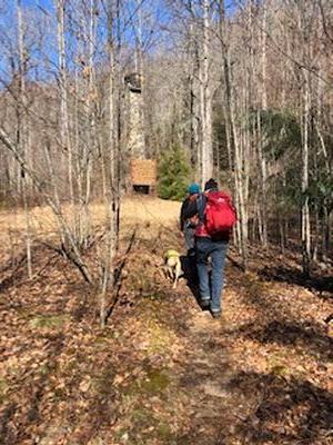
Sunday No. A1901-532-4652 Feb 10, 2019
Sassafras Mountain 8:00 AM
Hike 9.0, Drive 85, 2400 ft. ascent, Rated B-AA,
Daisy Teng Karasek, 828-505-2036, cell 408-887-3666, daisytk@yahoo.com
First Meeting Place: Toys-R-Us on NC 191 across from Asheville Outlets.
Second Meeting Place: Pisgah Forest Bi-Lo at 8:30 AM
This is a pleasant hike from US 178 up to the highest peak in South Carolina, following the Foothills Trail.
Topo(s): Eastatoe Gap
hike report:
Six members joined me for this hike. We were at the trailhead at 9:15 under an overcast sky. The forecast 50% chance of rain materialized first as a fine mist as we left Balancing Rock after our break. By the time we reached the summit right before noon, it was a steady light rain. We took shelter next to the rhododendrons below the summit and enjoyed our lunch. No views this time. The attached photo shows the happy group at the end of the hike at 2:45, no worse for wear after a mostly wet day out.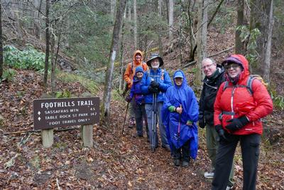
scout report:
I led this hike on Wednesday, December 19 with 11 people participating. The generally well-maintained trail was punctuated by downed trees from recent storms, creating an obstacle course with varying degrees of difficulty for hikers. I expect similar conditions when we tackle the same route on February 10. The views from the summit will be worth the climb. Please be sure to check Breaking News to find out if weather conditions will be affecting this hike.Sunday No. A1901-691-4675 (canceled) Feb 17, 2019
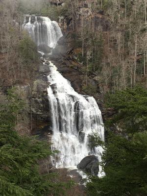
Upper Whitewater Falls - Round Mtn. Gap 8:00 AM
Hike 8.0, Drive 120, 1000 ft. ascent, Rated B-C, wc100
Donna Lanning, 828-606-7956, dblanning@bellsouth.net
First Meeting Place: Toys-R-Us on NC 191 across from Asheville Outlets.
Second Meeting Place: Pisgah Forest Bi-Lo at 8:30 AM
Form carpools and meet leader at second meeting place. We will follow the Foothills Trail west from the NC 281 parking lot to Round Mountain Gap, then follow the Round Mountain trail back to the Whitewater Falls overlook. From here we will drop steeply on the Foothills Trail east, cross the Whitewater River bridge, and later turn right and uphill on a short spur trail to the Bad Creek parking area. Short car shuttle.
Topo(s): Reid
scout report:
I’ve scouted this hike and found it to be very diverse in a very good way. The initial moderate climb shows beautiful views of Lake Jocassee. There are nice new stairs leading down to Whitewater Falls overlook that were rebuilt in 2017 due to 2016 wildfires. There is one water crossing that involves some boulder scrambling and hopping so bring your agility skills and shoes that grip well, it’s fun! We are able to see and hear Whitewater Falls for quite a stretch and will follow the river for the last few miles as well. Note: there is quite a bit of descent by trail and stairs but nothing difficult. This hike replaces the Cedar Rock/Butter Gap hike originally scheduled for this date. Donna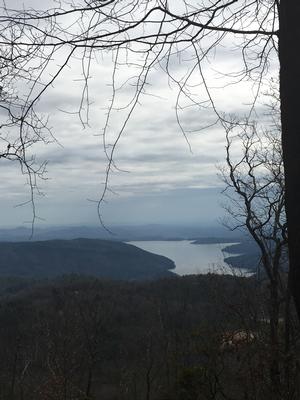
hike report:
Saturday No. A1901-224-4658 (canceled) Feb 23, 2019
Table Rock - Pinnacle Loop 8:00 AM
Hike 10.8, Drive 111, 3200 ft. ascent, Rated A-AA+,
Brenda Worley, 828-684-8656, cell 828-606-7297, bjdworley@gmail.com
First Meeting Place: Asheville Outlets parking lot behind Waffle House off Exit 33 of I-26.
Second Meeting Place: Cracker Barrel Restaurant off Exit 53 of I-26 in parking lot close to I-26 at 8:15 AM
This is a great hike with good views and warmer weather in South Carolina. Starting from the Nature Center parking lot at Table Rock State Park, our first objective will be Bald Rock near Pinnacle Mountain with glorious views. Then after a climb to Pinnacle Mountain for lunch, we’ll walk the ridge line to Table Rock with more great views, then steeply down to our cars. $5 per person fee.
Topo(s): Table Rock
Sunday No. A1901-374-4649 Feb 24, 2019
Good Road to MST to Bald Knob 8:00 AM
Hike 9.5, Drive 80, 2500 ft. ascent, Rated A-AA, at-mst
Eva Blinder, 828-275-6447, ejb5711@gmail.com
First Meeting Place: River Ridge Market Place behind CVS off Exit 53B of I-40.
Second Meeting Place: Ingles off Exit 64 of I-40 (Black Mountain) at 8:15 AM
Park on Good Road in McDowell County off US 221. Hike on MST to North Fork of Catawba River, cross bridge, and ascend to top of Bald Knob. A steep hike, but spectacular winter views. This hike offers an opportunity to see how the forest has recovered from a forest fire 3 years ago. Return by same route.
Topo(s): Little Switzerland
hike report:
We had a small but enthusiastic group for today's hike on the MST north of Lake James, a section we don't often visit. This section is considered one of the most strenuous on the entire MST, and it did not disappoint. An easy warmup quickly gives way to a steep climb up to Bald Knob, our lunch spot. Morning clouds gave way to warm sun as we made our way up, revealing beautiful views of the lake and the Black Mountains. Despite the recent rains, only a few short sections of the trail were wet or muddy. The wind kicked up when we reached the summit and continued until we were most of the way down.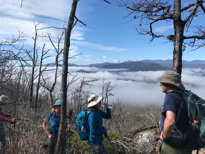
scout report:
I scouted this tough but rewarding hike on a beautiful February 14, ably assisted by Danny Bernstein. This trail has a little of everything, with varied terrain and trail surfaces, views of the mountains and the river, and a steep, rocky climb to the summit. A large portion of the trail was affected by forest fires a few years back, and there's plenty of evidence, although also signs of regeneration. As you approach the top, there are more blowdowns and trail debris, although nothing very hard to get past. The main challenge is the steep climb. Bring poles and plenty of water.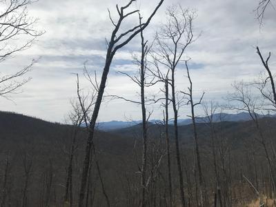
Sunday No. A1901-273-4609 Mar 03, 2019
Boogerman Trail 8:30 AM
Hike 8.0, Drive 90, 1100 ft. ascent, Rated B-B,
Bob Hysko, cell 828-243-3630, rhysko@yahoo.com
Only Meeting Place: Home Depot off Exit 44 of I-40. A lush forest with giant old-growth trees, stone walls and a root cellar make this a favorite loop hike in the Cataloochee area of the Smokies. We’ll cross Caldwell Fork ten times, mostly on rocks placed in the stream, but wet feet are possible if water level is high. Bring poles.
Topo(s): Cove Creek Gap
Sunday No. A1901-282-4647 Mar 10, 2019
Black Mountain - Avery Creek Loop 9:00 AM
Hike 10.6, Drive 80, 3000 ft. ascent, Rated A-AA, p400,wc100
Michael Cornn, 828-458-1281, mwcornn@gmail.com and Kathy Cornn/Kyle, 828-458-1282, katherinenkyle@gmail.com
First Meeting Place: Toys-R-Us on NC 191 across from Asheville Outlets.
Second Meeting Place: Pisgah Forest Bi-Lo at 9:30 AM
Note: First day of DST. Form carpools and meet leader at second meeting place. Climb up the Black Mtn. Trail (short in-and-out at Pressley Gap to view old chimney) over Black Mtn. and Clawhammer to Buckhorn Gap, then left and down on Buckhorn Gap Trail to Twin Falls. At trail T-intersection, do an in-and-out to falls. On return, continue on Buckhorn Gap - Avery Creek Trails to FS 477; turn R and walk FS 477 1/4 mile to cars.
Topo(s): Pisgah Forest
hike report:
Ten hikers, including one first-time hiker with the club from Virginia, completed the Black Mountain and Avery Creek hike with no drama or mishaps. We did encounter about nine cyclists while climbing Black Mountain, but we saw them coming and let them cruise down the trail before resuming. We had lunch at ClawHammer with a pristine view of Looking Glass Rock and the parkway. Twin Falls were particularly full and the bridges crossing Avery Creek were needing repair, but the plethora of rain this winter did not make any crossings - even the rockhops- difficult. After the hike four of us ate at Wild Ginger in Asheville.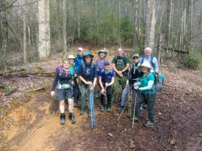

Saturday No. A1901-182-4600 Mar 16, 2019
Green River Cove Trail 10:00 AM
Hike 7.0, Drive 75, 1000 ft. ascent, Rated B-C,
Marcia Bromberg, 828-505-0471, cell 860-798-9905, mwbromberg@yahoo.com
First Meeting Place: Toys-R-Us on NC 191 across from Asheville Outlets.
Second Meeting Place: Cracker Barrel Restaurant off Exit 53 of I-26 in parking lot close to I-26 at 10:30 AM
This is a moderate in-and-out hike along the scenic Green River to the end of the trail near the "narrows”. Expect early wildflowers and maybe even kayakers on the river.
Topo(s): Cliffield Mtn,Cliffield Mtn
Sunday No. A1901-842-4602 Mar 17, 2019
Kitsuma - Swannanoa Creek Trail 8:00 AM
Hike 9.5, Drive 60, 1900 ft. ascent, Rated A-A,
Jim Reel, 828-443-2532, jimr57@yahoo.com
First Meeting Place: River Ridge Market Place behind CVS off Exit 53B of I-40.
Second Meeting Place: Ingles off Exit 64 of I-40 (Black Mountain) at 8:15 AM
Form carpools and meet leader at second meeting place. Leave cars at Point Lookout Trailhead. Hike down road to Old Fort Picnic Area, then follow trail up Young's Ridge and over Kitsuma Peak. Follow trail to 100 yds. before trailhead, then do a difficult 0.7 mile bushwhack down to Swannanoa Creek, and follow old stagecoach route (heavily overgrown) paralleling Swannanoa Creek. The road slowly improves and ends at its junction with the Point Lookout Trail (old US 70), which we will follow for a short distance to trailhead and our cars.
Topo(s): Old Fort
hike report:
Sunday morning was cold, crisp and sunny. A nice day to explore Swannanoa Creek and the Royal Gorge. Nine of us had an enjoyable hike as we talked about he history of the gorge, criss-crossed the creek and surveyed flood damage from 2018. Several trees had slid off the steep hillside above us and below the railroad high above. We crossed several new large washouts of the railroad drainage. The highlight of the day was when we found that Mother Nature had dammed the creek and built a small lake! We checked out civil war graves and observed relics of a time gone by. At this time of year old homesites are easy to locate. The beautiful daffodils of different varieties give the locations away. Thanks to everyone who attended for an awesome day!!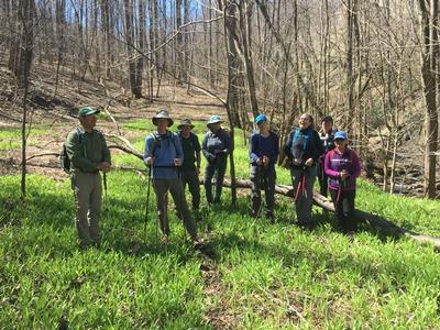
Sunday No. A1901-236-4603 Mar 24, 2019
Fawn Lake P.L. #1 8:00 AM
Hike 10.0, Drive 90, 1400 ft. ascent, Rated A-B, wc100
Danny Bernstein, 828-450-0747, dannyhiker@gmail.com
First Meeting Place: Toys-R-Us on NC 191 across from Asheville Outlets.
Second Meeting Place: Pisgah Forest Bi-Lo at 8:30 AM
A moderate hike featuring beautiful lakes and a waterfall. We'll see Bridal Veil Falls, Lake Julia, Lake Dense and Fawn Lake.
Topo(s): Standingstone Mtn
hike report:
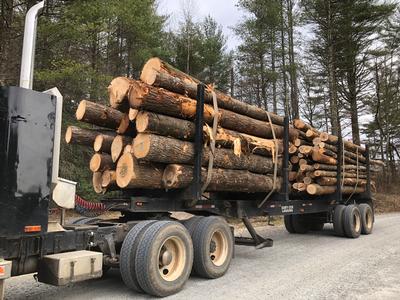
Twelve hikers came on a circular hike in Dupont State Recreational Forest. We started and ended at Fawn Lake, an unusual entrance. During the hike, the leader talked about the history of Dupont. Hikers really appreciated understanding a little about where they were walking. It was a good, cohesive group. Dupont is always a good, reliable, easy place to hike.
scout report:
Eva B. and I scouted this Dupont Forest hike, starting at the Fawn Lake entrance. We took little-known trails to arrive to Corn Mill Shoals and then Bridal Veil Falls. There's a surprising amount of climbing at the beginning of the hike but otherwise, it's a moderate hike. We'll see three lakes as well. We passed a fully loaded logging truck, which reminds us that Dupont is a forest.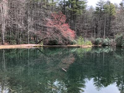
Saturday No. A1901-479-4599 Mar 30, 2019
Kagle Mountain 8:00 AM
Hike 9.0, Drive 80, 1100 ft. ascent, Rated B-B, p400
Sharon Smith, 704-877-7804, waltersharon204@gmail.com
First Meeting Place: Ingles on NC 191 across from Asheville Outlets Mall.
Second Meeting Place: Pisgah Forest Bi-Lo at 8:30 AM
This loop hike will start from Cathey's Creek Rd. and follow an overgrown forest road to the Art Loeb Trail, with lunch at the Butter Gap shelter. We'll return via a no-name trail for variety. Nice views.
Topo(s): Rosman
scout report:
Weds. March 20th, Judy and Sally joined me to scout this hike. It was new to me so I thought I might need help. The weather was great! We down loaded our tracks and away we went. After .7 miles on Cathy Creek Road it becomes dirt, with some ruts, so we needed high clearance, The first 5 miles is a gradual incline on an old logging road with good footing. Then we take a connector trail for a short distance to meet with the Art Lobe Tr. Which was all new to me and in good condition. Had lunch at Butter Cap shelter. Then a no name trail back to the FS road for a lollipop track. What great views of cedar mountain , I never seen before. I enjoyed these trails, and I know you will too.9.5 miles with 1900 ft. gainhike report:
Sunday No. A1901-355-4598 Mar 31, 2019
Devil Fork Gap to Carmen 8:00 AM
Hike 11.3, Drive 95, 2400 ft. ascent, Rated A-AA, at-mst
Tish Desjardins, 828-380-1452, desraylet@aol.com
First Meeting Place: 160 Zillicoa St. (USFS parking lot) off Exit 25 of I-26.
Second Meeting Place: US 25/NC 208 intersection at 8:45 AM
Form carpools and meet leader at second meeting place. Hike along nine of the most scenic miles on the A.T., featuring two shelters, a historic grave site and beautiful views from atop Big Butt. After the Jerry's Cabin shelter, we'll turn left and go down the Fork Ridge Trail to the parking lot in the Carmen area. Car shuttle. Please bring enough cars so that each passenger is safely belted to and from each car shuttle trailhead.
Topo(s): Greystone