ALL-DAY WEEKEND
Monday No. A1801-893-4218 (canceled) Jan 01, 2018
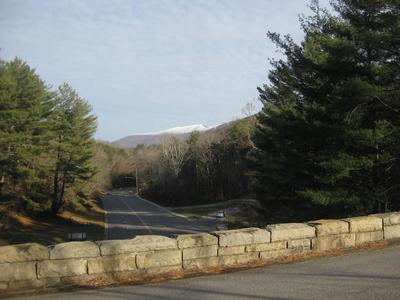
Green River Game Lands - West Side 7:30 AM
Hike 6.5, Drive 60, 1200 ft. ascent, Rated B-B,
Bruce Bente, 828-692-0116, cell 828-567-9443, bbente@bellsouth.net
First Meeting Place: Toys-R-Us on NC 191 across from Asheville Outlets.
Second Meeting Place: NE corner of Cracker Barrel off Exit 53 of I-26 at 8:00 AM
Meet leader at second meeting place. After breakfast at Cracker Barrel, we'll leave at 9:15 AM and hike our traditional New Year's Day hike in the Green River Game Lands. This year's hike will follow a different route which will be shorter but will still include lunch at the end of the Green River Cove trail by the big rocks in the Green River.
Topo(s): Cliffield Mtn
hike report:
After encountering icy roads on New Years Eve and 11 degrees on New Years Day, six of us met for breakfast at Cracker Barrel and decided that hiking was not a good idea. In 18 years, this is the first time we encountered weather this severe on NYD. Lets hope for better weather on NYD 2019! Brucescout report:
EVERYONE PLEASE WEAR BLAZE ORANGE! This year we will hike a different route, in order to avoid the hunters who are mostly in the eastern part of the game lands. However, let's all wear orange to be extra safe. Our route this year will enter on the Bishop Branch trail and wind our way down to the big rocks on the Green River for our lunch spot. We'll hike out on the Pulliam Creek Trail and then walk 1/4 mile on Big Hungry Rd. to our waiting cars. This year's route will be shorter, about 6-1/2 miles, and we'll be done hiking by about 2 pm. As usual, come to breakfast at Cracker Barrel regardless of weather. We'll enjoy the first meal of 2018 with friends, even if weather prevents us from hiking. See y'all on NYD, BruceSunday No. A1801-595-4252 Jan 07, 2018
Lake Imaging P.L. #4 - 3 Waterfalls and 3 Lakes 8:30 AM
Hike 9.0, Drive 85, 1140 ft. ascent, Rated B-B, wc100
Karen Lachow, 703-395-5879, heyk127@hotmail.com
First Meeting Place: Toys-R-Us on NC 191 across from Asheville Outlets.
Second Meeting Place: Pisgah Forest Bi-Lo at 9:00 AM
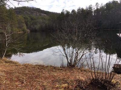
Between the Lake Imaging and Buck Forest parking lots we will visit Lake Imaging, Grassy Creek Falls, Lake Dense, Lake Alford, High Falls and Triple Falls.
Topo(s): Standingstone Mtn
hike report:
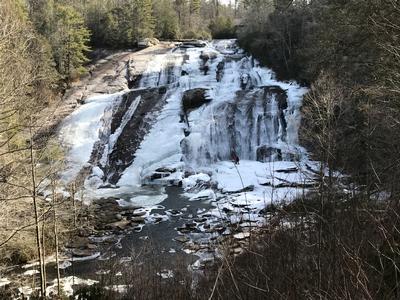
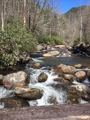
Eleven brave and hardy hikers layered up for this rare opportunity to see 3 frozen waterfalls and lakes in DuPont State Forest following over a week of sub-freezing temperatures. Starting out in 12 degrees after an obligatory group photo, the herd of cats took off fast to get moving and warm up their blood. Since this hike was changed only the day before from the originally scheduled “too cold to climb to 4700 feet” hike and had not been scouted, the group finally stopped at the first crossing to let their leader with the map and directions take the front. The trails were clear and dry and we moved quickly to reach Grassy Creek Falls. The frozen falls were amazingly beautiful on this sunny day and the icy lakes smooth as glass. We lunched at the picnic shelter on the edge of Lake Dense where the ice moaned and groaned like an animal was under the ice. Our previously warmed up fingers quickly got too cold so we didn’t linger any longer than we had to. High Falls (photo below) and Triple Falls were the highlights of the day, both a frozen winter wonderland. We skipped the optional bushwhack and finished for a total of 8.75 miles with 1165 ft. elevation gain. The day ended early around 2:30pm in a balmy 34 degrees.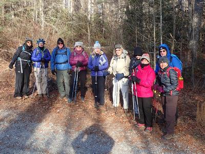
Saturday No. A1801-499-4230 Jan 13, 2018
Greenways around Asheville 10:00 AM
Hike 7.0, Drive 5, 100 ft. ascent, Rated B-C,
Marcia Bromberg, 828-505-0471, cell 860-798-9905, mwbromberg@yahoo.com
Only Meeting Place: Parking lot on Craven St. just north of New Belgium Brewery (west side of river). This hike follows current and future greenways along Hominy Creek and the French Broad River. We'll hike from the historic Sulphur Springs on dirt paths (may be muddy in spots) and pavement. On the way you'll learn about plans for a county-wide greenway system. For those who are interested, we'll end with a beer at the New Belgium Liquid Center. Car shuttle.
Topo(s): Asheville
hike report:
Only one taker for on a very, very cold day! Eloise and I were joined by Brotherhug Barlow who gave us the history of Sulphur Springs, the future Canie Creek Greenway and the Hominy Creek Greenway. Then we set off briskly by ourselves to complete our greenway walk, taking a short break in the heated Carrier Park ladies restroom for lunch.
Sunday No. A1801-892-4219 Jan 14, 2018
MST around Asheville 9:00 AM
Hike 13.7, Drive 20, 2050 ft. ascent, Rated AA-AA, at-mst
Les Love, 828-230-1861, lesrlove55@gmail.com
Only Meeting Place: Back parking lot of Folk Art Center. Note later meet time. Great workout hike for the winter over the rolling Biltmore section of the MST. Car shuttle.
Topo(s): Asheville
hike report:
It was 18 degrees when the five of us started at the French Broad O/L and 28 when we finished at the Folk Art Center. Debbie Jones had the great idea that we warm up for lunch at the Fresh Market Cafe on Hendersonville Road, getting there just after noon on the short trail that goes from the MST down to the Diamond Brand Shopping Center. Good ice formations on the Parkway and a stimulating 14 mile hike with views of peaks capped with rime ice.
scout report:
Sunday No. A1801-631-4233 Jan 21, 2018
High Falls P.L. #2 - Triple, High, Bridal Veil Falls & 2 lakes 8:30 AM
Hike 10.0, Drive 70, 1500 ft. ascent, Rated A-B, wc100
Judy Magura, 828-606-1490, quilter290@gmail.com and Jim Magura, 828-606-3989, jqs290@gmail.com
First Meeting Place: Ingles on NC 191 across from Asheville Outlets.
Second Meeting Place: Pisgah Forest Bi-Lo at 9:00 AM
This hike goes to three of the best waterfalls and two lakes in DuPont Forest. We will go to Triple and High Falls and then to Lake Dense. After lunch at the lake, we'll use Conservation Rd. and cross the dam at Lake Julia. We'll hike to the beautiful Bridal Veil Falls, and then Lake Julia Rd. After a stop at the picnic tables overlooking the lake, we'll return via Conservation and Buck Forest Roads.
scout report:
We found this easy to moderate hike through the DuPont State Forest to be quite rewarding with great views of 3 cascading waterfall and picturesque lakes. Temperature started off a bit chilly at 19 degrees but we quickly warmed up with a full sun and climbing temperatures. The scout hike came in at 10.1 miles and a 500 foot elevation gain from bottom to top was just right for this hike. Pack your lunch, weather looks promising for Sunday and join us for a hike that just what you need to take away the winter blues. Jan, Bruce, Sharon, Kevin and Sophie (The pooch) joined us for this early winter hike. TC was here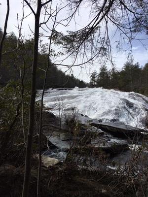
hike report:
Following introductions, we were pleasantly surprised to find a guest from Galway, Ireland (Sean Rooney) joining our hiking group for our 10 mile excursion in the DuPont State Forest. Sean is first on the left in the back row in our group photo and is an avid hiker. We were all quite lucky to have him join us as he shared a considerable amount of information on his home country during the hike and his perspective of the US. Sean was in town on business and found our hike through the CMC web site. We kicked off the hike at 9:45 and got back to the trail head at 3:10p. Weather was awesome as the high was 67 degrees and just perfect for a mid-winter hike. It was one of the few we have had with such great conditions. After all, the high could have been 17 degrees! There was a bit of ice was on the trails during the early morning hours, but posed no real problems for us during the day. We took in all three waterfalls, and enjoyed lunch and breaks in beautiful settings (lake Julia was simply awesome). Bruce added some insight was a great story on the property and pointed out some landmarks which only added to the enjoyment of the day.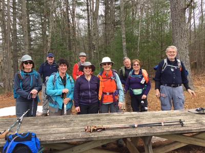
Saturday No. A1801-418-4245 (canceled) Jan 27, 2018
Newton Bald, Kanati Fork 8:00 AM
Hike 11.5, Drive 130, 3800 ft. ascent, Rated A-AA+,
Jeff Mcgurk, 864-921-6469, jbsbestfan@hotmail.com
Only Meeting Place: Home Depot off Exit 44 of I-40. This great winter hike climbs Kanati Fork Trail, then follows Thomas Divide Trail and descends on the Newton Bald Trail. Nice scenery and more fun if we hike up into snow-covered scenery. Short car shuttle.
Topo(s): Clingmans Dome,Smokemont
Sunday No. A1801-56-4229 (canceled) Jan 28, 2018
Turkey Pen Roller Coaster 8:30 AM
Hike 9.4, Drive 60, 3200 ft. ascent, Rated A-AA+, p400
Michael Cornn, 828-458-1281, mwcornn@gmail.com and Kathy Cornn/Kyle, 828-458-1282, katherinenkyle@gmail.com
First Meeting Place: Toys-R-Us on NC 191 across from Asheville Outlets.
Second Meeting Place: intersection of NC 280 and Turkey Pen Rd. at 9:00 AM
Form carpools and meet leaders at second meeting place. This great winter hike starts at Turkey Pen parking area, climbs over Sharpy Mountain, along a ridge and almost to the top of Black Mountain, ending at the Pisgah Maintenance parking lot. A long uphill, but with good views from our lunch spot at Black Mountain. Car shuttle.
Topo(s): Pisgah Forest
Sunday No. A1801-480-4224 (canceled) Feb 04, 2018
Buck Spring to US 276 via Barnett Branch Trail 7:30 AM
Hike 11.9, Drive 70, 2000 ft. ascent, Rated A-AA, p400
Donna Lanning, 828-606-7956, dblanning@bellsouth.net
First Meeting Place: Toys-R-Us on NC 191 across from Asheville Outlets.
Second Meeting Place: Pisgah Forest Bi-Lo at 8:00 AM
Form carpools and meet leader at second meeting place. This strenuous hike will start at the Buck Spring Trailhead on US 276 and hike down to the maintenance yard via a series of trails. It will feature great views from Clawhammer and Black Mountains along the way. Car shuttle.
Topo(s): Shining Rock
scout report:
I’ve changed this hike a bit to avoid descending the Black Mountain trail that is so popular with mountain bikers. We will begin at the Buck Spring trailhead as described in the original description and hike to the Black Mountain trail. After a short walk on that trail to a pretty spot for lunch, we will hike back to the Buck Spring trailhead. This hike is still moderate with a couple good climbs and steady inclines. It should be around 10 miles, give or take. We will spend the majority of the day on Barnett Branch trail which is nicely diverse with winter views and several waterfalls. The day we scouted we saw a lot of cat tracks in the snow! Interesting that if not for the snow we would not have known one had been through the area...hike report:
Saturday No. A1801-588-4240 (canceled) Feb 10, 2018
Coontree Loop Extended 10:00 AM
Hike 7.0, Drive 65, 1700 ft. ascent, Rated B-A, p400
Sharon Smith, 704-877-7804, waltersharon204@gmail.com
First Meeting Place: Toys-R-Us on NC 191 across from Asheville Outlets.
Second Meeting Place: Pisgah Forest Bi-Lo at 10:30 AM
We'll hike the Coontree Loop but extend it by including the Perry Cove and Bennett Gap Trails, with a short walk on FS 477 to connect the two.
Topo(s): Shining Rock
hike report:
Sunday No. A1801-894-4225 (canceled) Feb 11, 2018
Mount Pisgah Ramble 9:00 AM
Hike 9.0, Drive 25, 3100 ft. ascent, Rated B-AA+, at-mst, p400
Paul Benson, 828-273-2098, PDBenson@charter.net
Only Meeting Place: Home Depot off Exit 44 of I-40. This exciting new CMC hike will start at Elk Pasture Gap and loop through the high country around Mt. Pisgah. Come and enjoy winter hiking at high elevations.
Topo(s): Dunsmore Mt
hike report:
Better late than never! I rescheduled this hike on 3/15 to take advantage of a sunny day. We started out with winter weather, however, as a late snowstorm dropped a light blanket of snow the day before and lows in the 20s froze the ground. High winds added to the winter-like feel. But as the day went on the winds blew in warmer temps. Views were excellent under bluebird skies. Interestingly, I stared with 9 hikers and ended up with 4. No one was lost or injured, just opted for shortcuts back for various reasons - the first of which was the big climb at the start of the hike - 2,400' in 2 miles!
Sunday No. A1801-778-4242 Feb 18, 2018
Bracken Mountain - Brushy Creek Trails 8:00 AM
Hike 7.8, Drive 65, 1400 ft. ascent, Rated B-B,
Lorraine Bernhardt, 828-699-8857, lsbernhardt50@gmail.com
First Meeting Place: Toys-R-Us on NC 191 across from Asheville Outlets.
Second Meeting Place: Pisgah Forest Bi-Lo at 8:30 AM
Form carpools and meet leader at second meeting place. This hike will include the Bracken Mtn. and Brushy Creek Trails. This is a great winter hike with good views.
Topo(s): Rosman,Shining Rock
hike report:
Eighteen hikers turned out on this beautiful and sunny day at Bracken Mountain Preserve. Long range views were enjoyed for much of the hike. A leisurely lunch was enjoyed at the pavilion built by eagle scouts. The trails were in good condition. A few other hikers and bikers were encountered. We especially enjoyed a break from the rain and the chance to enjoy a Sunday hike again!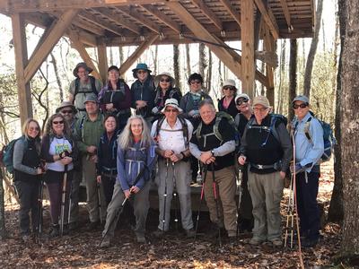
scout report:
Donna L. and I scouted this pleasant hike with good winter views. Despite heavy rains the previous day, the trail was dry. We will hike up to the border of Pisgah National Forest, then backtrack to a loop, returning to the trail head by way of Brushy Creek trail. There is a lovely covered deck built by eagle scouts where we will have lunch. This is also a biking trail but hopefully our early start will minimize contact. This hike should be finished by early afternoon.Saturday No. A1801-246-4236 Feb 24, 2018
Coffee Pot Mountain Loop 9:00 AM
Hike 7.5, Drive 50, 1400 ft. ascent, Rated B-B, p400
Barbara Morgan, 828-460-7066, barbc129@gmail.com
First Meeting Place: Toys-R-Us on NC 191 across from Asheville Outlets.
Second Meeting Place: Ingles on NC 191/280 in front of gas pumps (Mills River) at 9:15 AM
We'll circle Coffee Pot Mtn. by hiking Trace Ridge Trail to Beaver Dam Gap on the BRP and returning on the Spencer Branch and Fletcher Creek Trails, with a stop to look at the Hendersonville reservoir and dam.
Topo(s): Dunsmore Mt
hike report:
Despite an iffy weather forecast, we had a great group of 17 hikers for this Saturday hike in the Mills River area. Turned out that the only drizzle was as we were driving, and the day was beautiful and unseasonably warm for the end of February (something like 70+ degrees). We did the loop counter-clockwise, same as in the scout, going from Trace Ridge Trail where we had lunch, to Spencer Branch Trail, and ending with Fletcher Creek Trail. The three stream crossings went just fine. We attempted to continue down Spencer Branch Trail to the dam on Mills River, but quickly found that there was a knee -deep, 15’wide crossing that sent us back to the Fletcher Creek Trail intersection as originally planned. The dam was a nice place to relax and snack, and we were surprised to see some folks swimming in the pool above the dam! That part was definitely worth the short side trip. There were more bikers on the trails than the few we’d seen on the mid-week scout and tho some came pretty fast, we managed to get ourselves off the trail in time. The hike was a little longer than listed on the website – instead of 7.5 miles and 1400’ elevation change, Kathy got 8.4 miles and 1600’ instead on her GPS (thanks, Kathy). We started about 9:45 and finished a little after 3:00. Great hike; great group! Thanks!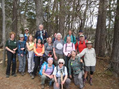
scout report:
Laura Frisbee and Sarah Oram helped me with this great loop hike in the Mills River area – thanks, guys! Since it wasn’t an official club hike, we allowed two of our dogs to come with us, and they had a great time. There were no trail issues found that would inhibit enjoyment of the hike, but if you come on the scheduled hike on Saturday Feb. 24, be aware that there are three stream crossings about an hour and a half before we’ll get back to the car. For the first two, we stayed pretty dry, but on the last I just walked through 6” deep water rather than risk slipping. We might be able to do some rock rearranging to stay dry. Water shoes? That’s up to you. The trail is varied and has good winter views – the first half is on Trace Ridge, and then an easy descent to the level of Spencer Branch for the return part of the loop. We saw no other hikers and maybe 3 mountain bikers, but on a Saturday there may be a few more. But, the hike is remote enough I wouldn’t expect to be inundated with either other hikers or bikers. We started about 9:50 and got back to the cars about 2:30.
Sunday No. A1801-596-4239 Feb 25, 2018
Laurel Fork Gap to Lake Jocassee 8:00 AM
Hike 10.8, Drive 90, 1400 ft. ascent, Rated A-B,
Laura Frisbie, 828-337-5845, laurafrisbie@gmail.com
First Meeting Place: Toys-R-Us on NC 191 across from Asheville Outlets.
Second Meeting Place: Pisgah Forest Bi-Lo at 8:30 AM
We'll hike the Foothills Trail in SC, from Laurel Fork Gap to Lake Jocassee. This in-and-out hike along Laurel Fork Creek features a beautiful stream, waterfalls, great bridges and a scenic lakeside lunch spot.
Topo(s): Reid
scout report:
Daisy took me and my doggies to scout this hike. It is a lovely soft trail hike (how many picturesque bridges can one hike have? I don't know, I lost count!) There is a 4 mile gravel road drive which together with the distance and length of the hike makes for a long day. Expect to return to your cars as late as 6:30, There had been plenty of rain and there were several rock hop crossings where feet get wet. There are steep steps at the beginning/end of the hike that can be slippery. Poles highly recommended.Sunday No. A1801-332-4237 Mar 04, 2018
Foothills Trail: Upper and Lower Whitewater Falls 8:00 AM
Hike 11.6, Drive 110, 2400 ft. ascent, Rated A-AA, wc100
Jim Magura, 828-606-3989, jqs290@gmail.com and Judy Magura, 828-606-1490, quilter290@gmail.com
First Meeting Place: Toys-R-Us on NC 191 across from Asheville Outlets.
Second Meeting Place: Pisgah Forest Bi-Lo at 8:30 AM
Come to hike in the warm weather at the lower elevations! We’ll hike part of the Foothills Trail in NC and SC, featuring two of the region’s most stunning waterfalls. We will begin at the Upper Whitewater Falls parking lot and hike to the footbridge over the Thompson River. We’ll partially retrace our steps, then take the side trail to Lower Whitewater Falls, and finish at the Duke Power Co. Bad Creek parking lot. Short car shuttle.
Topo(s): Reid
scout report:
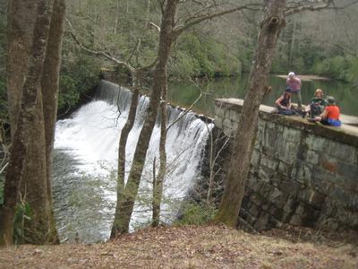
Scout Report: Judy and I scouted the Hike with Chris Koebelin and the three of us decided to modify the hike based on hike distance, elevation gain and driving time. First we are not doing the hike shuttle, and second we are adding the upper falls as a option at the end of the hike. The new route will take us out to the lower falls (photo) and then on to Thompson River for lunch. The revised hike comes in at 8 miles and 2000 feet elevation without the side trip to the Upper Falls at the end of the hike. Following return to the lower falls parking lot we can do an optional stop along the foothills trail with a 1.3 mile round trip hike to the Upper-falls. We would classify the hike as moderate, the uphill climb from Thompson River (Photo) will exercise those winter muscles if you have taken a hiking break.hike report:
A perfect day for eleven hikers who ventured out for a surprisingly pleasant March day . From the lower parking lot we hiked out to the lower falls and noted the plane wreckage which was still visible on the left side of the spectacular falls. I attempted to get a group picture without much success, but I did capture proof that we were all there. No danger on the trails, but signs posted. Following an extended break and a bit of hunting for a misplaced cell phone, we were off to the Robinson river for our lunch break. With a little searching, the phone was found in an identical back pack as well as a good laugh and a great lesson learned. Arriving at the Robinson River at 12:30, we took an extended lunch break which gave Judy a little extra time to locate the .4 mile trail up to Big Falls for a possible side trip. No luck as the old trail was blocked with downed trees, boulders and brush along the river. Judy did get an A-plus for effort. We returned to the parking lot after a steep climb and logged in 9.3 miles and 2156' vertical for the hike. Four hikers did drive and take in the views Upper Falls before we returned to Asheville.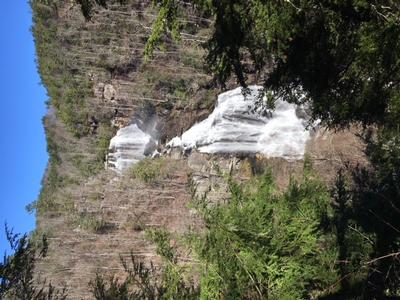
Saturday No. A1801-256-4235 Mar 10, 2018
Moore Cove Figure-8 Loop 10:00 AM
Hike 7.0, Drive 65, 1050 ft. ascent, Rated B-B, p400,wc100
Brenda Worley, 828-684-8656, cell 828-606-7297, bjdworley@gmail.com
First Meeting Place: Ingles on NC 191 across from Asheville Outlets.
Second Meeting Place: Pisgah Forest Bi-Lo at 10:30 AM
Form carpools and meet leader at the second meeting place. This moderate double-loop trail follows two overgrown USFS paths. Expect a lot of scrambling over blowdowns, a couple of short, steep sections and two minor creek crossings. There is one good view of Looking Glass Rock, several waterfalls, and other views visible only when there are no leaves on the trees.
Topo(s): Shining Rock
hike report:
Nine of us showed up and were delighted by this challenging and interesting hike. Thank goodness for Bruce who was the only one who knew all the turns and twists of this hike. He also had the experience to help us negotiate the many blow downs as well as knowing how to find the manways to the lovely little waterfalls on the trail. After the bushwhack up the bank to the unmaintained trail, we came to a group of men dressed in camouflage jackets who were repelling off the side of the mountain. These were the only other people we saw on the trail until we came out beside the Moore Cove Falls. The weather was great which allowed for great views. This one is a keeper even if the trail is no longer maintained. Hopefully we can hike it enough to keep the trail visible.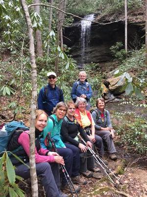
Sunday No. A1801-842-4247 Mar 11, 2018
Kitsuma - Swannanoa Creek Trail 8:30 AM
Hike 9.0, Drive 60, 1900 ft. ascent, Rated B-A,
Jim Reel, 828-443-2532, jimr57@yahoo.com
First Meeting Place: River Ridge Market Place behind CVS off Exit 53B of I-40.
Second Meeting Place: Ingles off Exit 64 of I-40 (Black Mountain) at 8:45 AM
NOTE: First day of Daylight Saving Time. Form carpools and meet leader at second meeting place. Leave cars at Point Lookout Trailhead. Hike down road to Old Fort Picnic Area; then follow trail up Young's Ridge and over Kitsuma peak; Follow trail to 100 yds. before trailhead, then do a difficult 0.7 mile bushwhack down to Swannanoa Creek; follow old stagecoach route (heavily overgrown) paralleling Swannanoa Creek. The road slowly improves and ends at its junction with the Point Lookout Trail (old US 70), which we will follow for a short distance to trailhead and our waiting cars.
Topo(s): Old Fort
Sunday No. A1801-394-4228 Mar 18, 2018
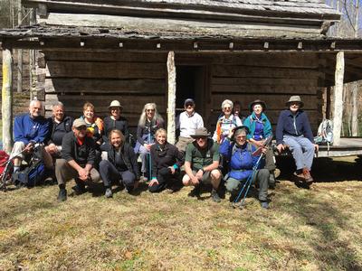
Cataloochee and Little Cataloochee 9:00 AM
Hike 8.0, Drive 95, 1500 ft. ascent, Rated B-B,
Danny Bernstein, 828-450-0747, dannyhiker@gmail.com
Only Meeting Place: Home Depot off Exit 44 of I-40. We'll hike from Cataloochee into Little Cataloochee on the Pretty Hollow and Little Cataloochee trails. We'll see a restored log cabin, the old apple house, an old church and maybe, just maybe, elk.
Topo(s): Cove Creek Gap
hike report:
Sixteen hikers joined to hike the Pretty Hollow Gap Trail to the Little Cataloochee Trail. Then we climbed up - up is the operative word - to Davidson Gap. Down, down, down to the Cooke Cabin and finally the Little Cataloochee Baptist Chape. Then we reversed our direction and headed back to the car. We had to cross a couple of unbridged water crossings. My boots were soaked but some were more agile and managed to make it across with dry feet.
scout report:
I scouted this hike with Marielle of Friends of the Smokies - www.friendsofthesmokies.org. We walked up Pretty Hollow Gap Trail where there were a couple of water crossings. Hiking poles will be helpful. Once on Little Cataloochee Trail, the trail was steep but well-maintained. The park is planning a prescribed burn in that area and we met a couple of employees blowing leaves off the trail. The highlights are the Cook Cabin and LIttle Cataloochee Chapel. For more details, see my blog at http://www.hikertohiker.net/2018/03/01/scouting-big-little-cataloochee/ So bring hiking poles (and maybe extra socks) and enjoy this historic area.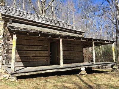
Sunday No. A1801-896-4241 Mar 25, 2018
Mingus Creek Trail 8:00 AM
Hike 7.0, Drive 120, 1000 ft. ascent, Rated B-C,
Mike Knies, 828-628-6712, knies06@att.net
First Meeting Place: Home Depot off Exit 44 of I-40.
Second Meeting Place: Maggie Valley Post Office at 8:30 AM - but contact leader first.
See historic Mingus Mill, an operating business, and learn about the history of former residents, with visits to their home sites and cemeteries. A pleasant walk with lots of interesting surprises along the way. We'll visit the Oconaluftee Visitor Center after the hike.
Topo(s): Smokemont
scout report:
The Mingus Mill Hike is being replaced by the Tight Run Poplar Flats hike in the same area within a few miles of the Oconaluftee Visitor Center. This new hike is about 7.5 miles long with gentle grades totaling about 1000 feet elevation. there are many historic sites along this pleasant route including home sites, cemeteries, stables, and surprises. Much of the trek is technically off trail as we will follow a former official park trail that was decommissioned in the late 70's and then we will be off trail in open forest with virtually no rhodo or laurel for a short distance. A visit to the nearby still operating Mingus Mill and or the Visitor Center is still on the itinerary if members of the group are interested. Meeting times and places are the same as originally scheduled.hike report:
Saturday No. A1801-51-4227 Mar 31, 2018
White Oak Flats, Pounding Mill, Hickey Fork 8:30 AM
Hike 8.0, Drive 85, 1900 ft. ascent, Rated B-A,
Tish Desjardins, 828-380-1452, desraylet@aol.com
First Meeting Place: 160 Zillicoa St. (USFS parking lot) off Exit 25 of I-26.
Second Meeting Place: US 25/NC 208 intersection at 9:00 AM
Form carpools and meet leader at second meeting place. Starting at the footbridge over Hickey Fork, we'll do a nice loop hike using three different trails and finishing on heavily rebuilt Hickey Fork Rd.
Topo(s): White Rock
hike report:
This was a beautiful sunny day for a hike after the prior day's heavy rainfall. Hence, Hickey Falls was gorgeous and rushing with all that water from the day before!!! We saw trilliums starting to come up, so, they should be in bloom in a few weeks! Beautiful views of Shelton Laurel were enjoyed.